You are here: Home > Network List > TA - USArray Transportable Network (new EarthScope stations) Stations List
> Station T53A Wise, VA, USA > Earthquake Result Viewer
T53A Wise, VA, USA - Earthquake Result Viewer

| Earthquake location: |
Southern Alaska |
| Earthquake latitude/longitude: |
62.0/-151.8 |
| Earthquake time(UTC): |
2014/09/25 (268) 17:51:17 GMT |
| Earthquake Depth: |
103 km |
| Earthquake Magnitude: |
6.2 ML, 6.1 MI, 6.2 MWW, 6.3 MWR, 6.3 MWB, 6.3 MWC |
| Earthquake Catalog/Contributor: |
NEIC PDE/NEIC COMCAT |
|
| Network: |
TA USArray Transportable Network (new EarthScope stations) |
| Station: |
T53A Wise, VA, USA |
| Lat/Lon: |
36.98 N/82.54 W |
| Elevation: |
818 m |
|
| Distance: |
48.6 deg |
| Az: |
87.468 deg |
| Baz: |
323.865 deg |
| Ray Param: |
0.068935394 |
| Estimated Moho Depth: |
16.25 km |
| Estimated Crust Vp/Vs: |
2.06 |
| Assumed Crust Vp: |
6.476 km/s |
| Estimated Crust Vs: |
3.144 km/s |
| Estimated Crust Poisson's Ratio: |
0.35 |
|
| Radial Match: |
87.484604 % |
| Radial Bump: |
400 |
| Transverse Match: |
67.49341 % |
| Transverse Bump: |
400 |
| SOD ConfigId: |
796777 |
| Insert Time: |
2014-10-09 18:33:06.135 +0000 |
| GWidth: |
2.5 |
| Max Bumps: |
400 |
| Tol: |
0.001 |
|
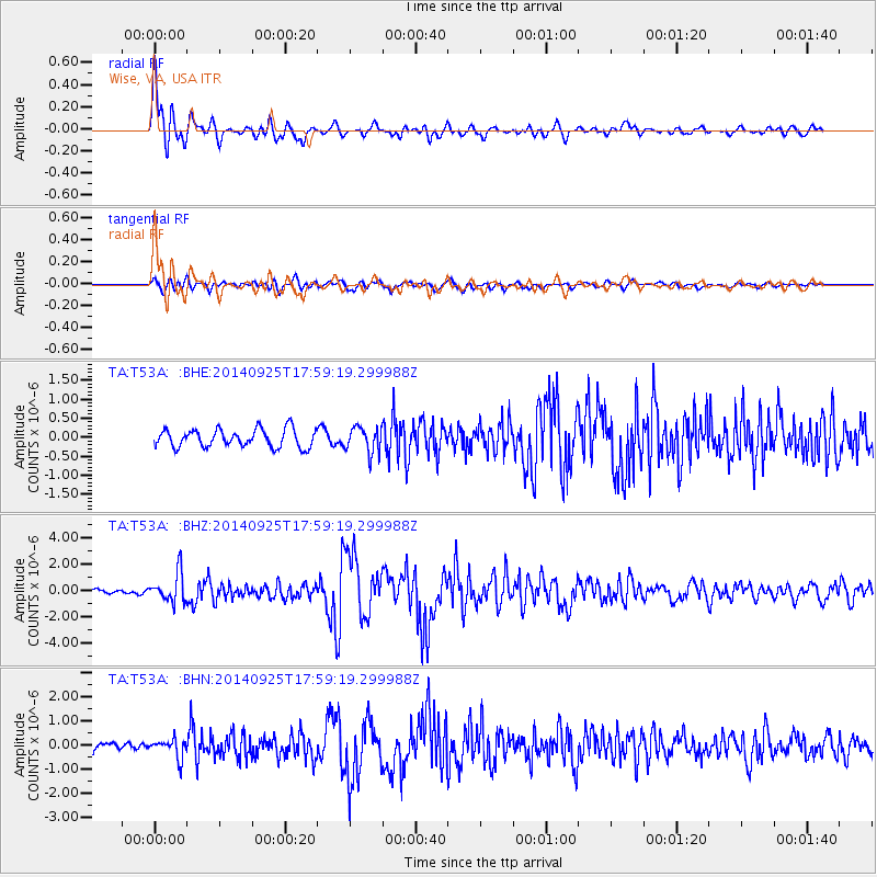
Signal To Noise
| Channel | StoN | STA | LTA |
| TA:T53A: :BHZ:20140925T17:59:19.299988Z | 4.122336 | 1.1085806E-6 | 2.6892047E-7 |
| TA:T53A: :BHN:20140925T17:59:19.299988Z | 2.124701 | 3.9101633E-7 | 1.8403358E-7 |
| TA:T53A: :BHE:20140925T17:59:19.299988Z | 1.4316975 | 3.3663628E-7 | 2.3513088E-7 |
| Arrivals |
| Ps | 2.8 SECOND |
| PpPs | 7.3 SECOND |
| PsPs/PpSs | 10 SECOND |


