You are here: Home > Network List > TA - USArray Transportable Network (new EarthScope stations) Stations List
> Station U56A King, NC, USA > Earthquake Result Viewer
U56A King, NC, USA - Earthquake Result Viewer
| Earthquake location: |
Southern Alaska |
| Earthquake latitude/longitude: |
62.0/-151.8 |
| Earthquake time(UTC): |
2014/09/25 (268) 17:51:17 GMT |
| Earthquake Depth: |
103 km |
| Earthquake Magnitude: |
6.2 ML, 6.1 MI, 6.2 MWW, 6.3 MWR, 6.3 MWB, 6.3 MWC |
| Earthquake Catalog/Contributor: |
NEIC PDE/NEIC COMCAT |
|
| Network: |
TA USArray Transportable Network (new EarthScope stations) |
| Station: |
U56A King, NC, USA |
| Lat/Lon: |
36.35 N/80.38 W |
| Elevation: |
363 m |
|
| Distance: |
50.1 deg |
| Az: |
86.111 deg |
| Baz: |
324.26 deg |
| Ray Param: |
0.06795173 |
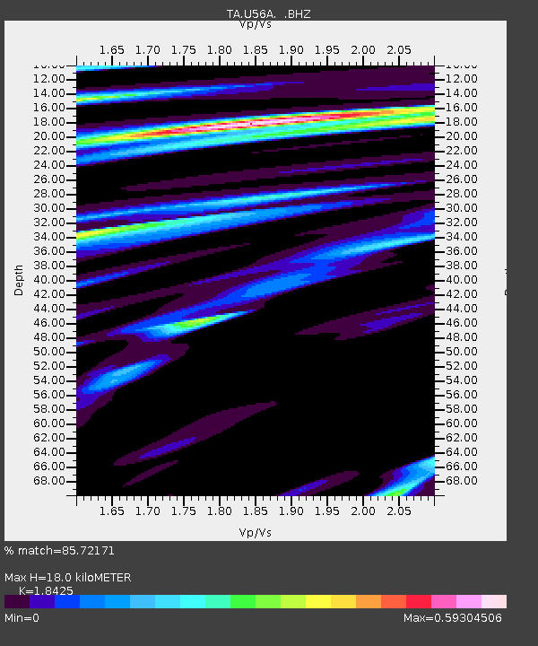
| Estimated Moho Depth: |
18.0 km |
| Estimated Crust Vp/Vs: |
1.84 |
| Assumed Crust Vp: |
6.159 km/s |
| Estimated Crust Vs: |
3.343 km/s |
| Estimated Crust Poisson's Ratio: |
0.29 |
|
| Radial Match: |
85.72171 % |
| Radial Bump: |
400 |
| Transverse Match: |
51.56692 % |
| Transverse Bump: |
400 |
| SOD ConfigId: |
796777 |
| Insert Time: |
2014-10-09 18:33:38.643 +0000 |
| GWidth: |
2.5 |
| Max Bumps: |
400 |
| Tol: |
0.001 |
|

Signal To Noise
| Channel | StoN | STA | LTA |
| TA:U56A: :BHZ:20140925T17:59:30.899994Z | 5.544796 | 9.69479E-7 | 1.7484484E-7 |
| TA:U56A: :BHN:20140925T17:59:30.899994Z | 1.9720361 | 5.0871665E-7 | 2.5796518E-7 |
| TA:U56A: :BHE:20140925T17:59:30.899994Z | 1.1733469 | 2.6973999E-7 | 2.2988938E-7 |
| Arrivals |
| Ps | 2.6 SECOND |
| PpPs | 7.9 SECOND |
| PsPs/PpSs | 10 SECOND |


