You are here: Home > Network List > TA - USArray Transportable Network (new EarthScope stations) Stations List
> Station X54A Belton, SC, USA > Earthquake Result Viewer
X54A Belton, SC, USA - Earthquake Result Viewer
| Earthquake location: |
Southern Alaska |
| Earthquake latitude/longitude: |
62.0/-151.8 |
| Earthquake time(UTC): |
2014/09/25 (268) 17:51:17 GMT |
| Earthquake Depth: |
103 km |
| Earthquake Magnitude: |
6.2 ML, 6.1 MI, 6.2 MWW, 6.3 MWR, 6.3 MWB, 6.3 MWC |
| Earthquake Catalog/Contributor: |
NEIC PDE/NEIC COMCAT |
|
| Network: |
TA USArray Transportable Network (new EarthScope stations) |
| Station: |
X54A Belton, SC, USA |
| Lat/Lon: |
34.55 N/82.37 W |
| Elevation: |
213 m |
|
| Distance: |
50.6 deg |
| Az: |
89.183 deg |
| Baz: |
325.07 deg |
| Ray Param: |
0.06761572 |
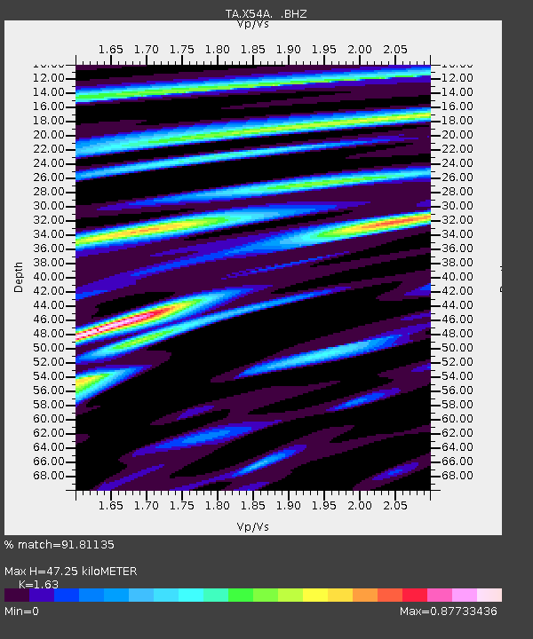
| Estimated Moho Depth: |
47.25 km |
| Estimated Crust Vp/Vs: |
1.63 |
| Assumed Crust Vp: |
6.35 km/s |
| Estimated Crust Vs: |
3.896 km/s |
| Estimated Crust Poisson's Ratio: |
0.20 |
|
| Radial Match: |
91.81135 % |
| Radial Bump: |
371 |
| Transverse Match: |
71.00252 % |
| Transverse Bump: |
400 |
| SOD ConfigId: |
796777 |
| Insert Time: |
2014-10-09 18:35:01.900 +0000 |
| GWidth: |
2.5 |
| Max Bumps: |
400 |
| Tol: |
0.001 |
|

Signal To Noise
| Channel | StoN | STA | LTA |
| TA:X54A: :BHZ:20140925T17:59:34.850006Z | 5.3773413 | 1.1424688E-6 | 2.124598E-7 |
| TA:X54A: :BHN:20140925T17:59:34.850006Z | 2.6574514 | 5.675568E-7 | 2.1357185E-7 |
| TA:X54A: :BHE:20140925T17:59:34.850006Z | 1.5318068 | 2.9286662E-7 | 1.9119031E-7 |
| Arrivals |
| Ps | 5.0 SECOND |
| PpPs | 18 SECOND |
| PsPs/PpSs | 23 SECOND |


