You are here: Home > Network List > TA - USArray Transportable Network (new EarthScope stations) Stations List
> Station X57A Johnson Farm, Hartsville, SC, USA > Earthquake Result Viewer
X57A Johnson Farm, Hartsville, SC, USA - Earthquake Result Viewer

| Earthquake location: |
Southern Alaska |
| Earthquake latitude/longitude: |
62.0/-151.8 |
| Earthquake time(UTC): |
2014/09/25 (268) 17:51:17 GMT |
| Earthquake Depth: |
103 km |
| Earthquake Magnitude: |
6.2 ML, 6.1 MI, 6.2 MWW, 6.3 MWR, 6.3 MWB, 6.3 MWC |
| Earthquake Catalog/Contributor: |
NEIC PDE/NEIC COMCAT |
|
| Network: |
TA USArray Transportable Network (new EarthScope stations) |
| Station: |
X57A Johnson Farm, Hartsville, SC, USA |
| Lat/Lon: |
34.46 N/80.09 W |
| Elevation: |
133 m |
|
| Distance: |
51.7 deg |
| Az: |
87.262 deg |
| Baz: |
325.152 deg |
| Ray Param: |
0.06687776 |
| Estimated Moho Depth: |
34.5 km |
| Estimated Crust Vp/Vs: |
1.75 |
| Assumed Crust Vp: |
6.419 km/s |
| Estimated Crust Vs: |
3.658 km/s |
| Estimated Crust Poisson's Ratio: |
0.26 |
|
| Radial Match: |
87.60002 % |
| Radial Bump: |
400 |
| Transverse Match: |
64.94691 % |
| Transverse Bump: |
400 |
| SOD ConfigId: |
796777 |
| Insert Time: |
2014-10-09 18:35:07.579 +0000 |
| GWidth: |
2.5 |
| Max Bumps: |
400 |
| Tol: |
0.001 |
|
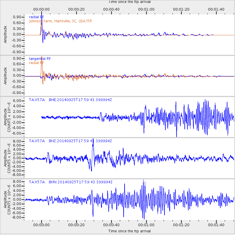
Signal To Noise
| Channel | StoN | STA | LTA |
| TA:X57A: :BHZ:20140925T17:59:43.399994Z | 4.7355676 | 1.0801862E-6 | 2.2810067E-7 |
| TA:X57A: :BHN:20140925T17:59:43.399994Z | 2.943048 | 7.517876E-7 | 2.5544523E-7 |
| TA:X57A: :BHE:20140925T17:59:43.399994Z | 2.7901642 | 6.579595E-7 | 2.3581389E-7 |
| Arrivals |
| Ps | 4.3 SECOND |
| PpPs | 14 SECOND |
| PsPs/PpSs | 18 SECOND |


