You are here: Home > Network List > TA - USArray Transportable Network (new EarthScope stations) Stations List
> Station Z57A Bowman, SC, USA > Earthquake Result Viewer
Z57A Bowman, SC, USA - Earthquake Result Viewer
| Earthquake location: |
Southern Alaska |
| Earthquake latitude/longitude: |
62.0/-151.8 |
| Earthquake time(UTC): |
2014/09/25 (268) 17:51:17 GMT |
| Earthquake Depth: |
103 km |
| Earthquake Magnitude: |
6.2 ML, 6.1 MI, 6.2 MWW, 6.3 MWR, 6.3 MWB, 6.3 MWC |
| Earthquake Catalog/Contributor: |
NEIC PDE/NEIC COMCAT |
|
| Network: |
TA USArray Transportable Network (new EarthScope stations) |
| Station: |
Z57A Bowman, SC, USA |
| Lat/Lon: |
33.30 N/80.70 W |
| Elevation: |
81 m |
|
| Distance: |
52.4 deg |
| Az: |
88.629 deg |
| Baz: |
325.653 deg |
| Ray Param: |
0.06644803 |
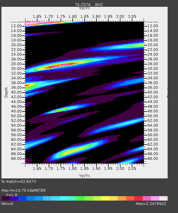
| Estimated Moho Depth: |
10.75 km |
| Estimated Crust Vp/Vs: |
1.60 |
| Assumed Crust Vp: |
6.565 km/s |
| Estimated Crust Vs: |
4.103 km/s |
| Estimated Crust Poisson's Ratio: |
0.18 |
|
| Radial Match: |
82.9473 % |
| Radial Bump: |
400 |
| Transverse Match: |
72.16572 % |
| Transverse Bump: |
400 |
| SOD ConfigId: |
796777 |
| Insert Time: |
2014-10-09 18:35:39.948 +0000 |
| GWidth: |
2.5 |
| Max Bumps: |
400 |
| Tol: |
0.001 |
|
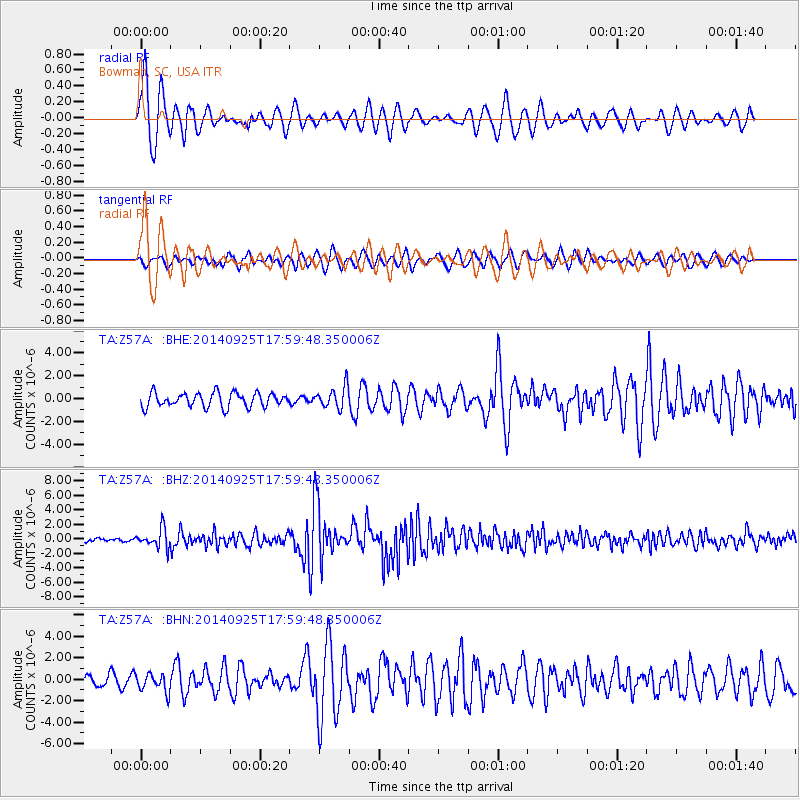
Signal To Noise
| Channel | StoN | STA | LTA |
| TA:Z57A: :BHZ:20140925T17:59:48.350006Z | 6.088048 | 1.339971E-6 | 2.2009863E-7 |
| TA:Z57A: :BHN:20140925T17:59:48.350006Z | 1.3761683 | 8.4556547E-7 | 6.144346E-7 |
| TA:Z57A: :BHE:20140925T17:59:48.350006Z | 1.5194583 | 9.538271E-7 | 6.2774154E-7 |
| Arrivals |
| Ps | 1.0 SECOND |
| PpPs | 4.0 SECOND |
| PsPs/PpSs | 5.0 SECOND |


