You are here: Home > Network List > TA - USArray Transportable Network (new EarthScope stations) Stations List
> Station Z59A Georgetown, SC, USA > Earthquake Result Viewer
Z59A Georgetown, SC, USA - Earthquake Result Viewer

| Earthquake location: |
Southern Alaska |
| Earthquake latitude/longitude: |
62.0/-151.8 |
| Earthquake time(UTC): |
2014/09/25 (268) 17:51:17 GMT |
| Earthquake Depth: |
103 km |
| Earthquake Magnitude: |
6.2 ML, 6.1 MI, 6.2 MWW, 6.3 MWR, 6.3 MWB, 6.3 MWC |
| Earthquake Catalog/Contributor: |
NEIC PDE/NEIC COMCAT |
|
| Network: |
TA USArray Transportable Network (new EarthScope stations) |
| Station: |
Z59A Georgetown, SC, USA |
| Lat/Lon: |
33.24 N/79.28 W |
| Elevation: |
8.0 m |
|
| Distance: |
53.1 deg |
| Az: |
87.429 deg |
| Baz: |
325.706 deg |
| Ray Param: |
0.06596896 |
| Estimated Moho Depth: |
12.0 km |
| Estimated Crust Vp/Vs: |
1.60 |
| Assumed Crust Vp: |
6.24 km/s |
| Estimated Crust Vs: |
3.9 km/s |
| Estimated Crust Poisson's Ratio: |
0.18 |
|
| Radial Match: |
81.43095 % |
| Radial Bump: |
400 |
| Transverse Match: |
70.509575 % |
| Transverse Bump: |
400 |
| SOD ConfigId: |
796777 |
| Insert Time: |
2014-10-09 18:35:47.466 +0000 |
| GWidth: |
2.5 |
| Max Bumps: |
400 |
| Tol: |
0.001 |
|
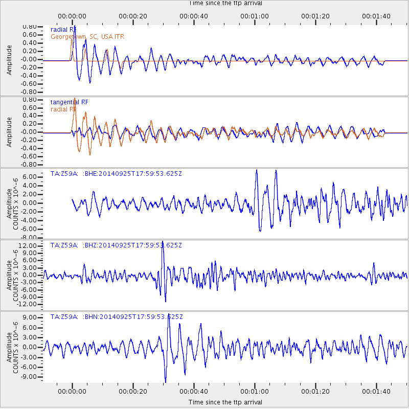
Signal To Noise
| Channel | StoN | STA | LTA |
| TA:Z59A: :BHZ:20140925T17:59:53.625Z | 2.6692195 | 1.713891E-6 | 6.420945E-7 |
| TA:Z59A: :BHN:20140925T17:59:53.625Z | 0.86927086 | 9.078212E-7 | 1.0443479E-6 |
| TA:Z59A: :BHE:20140925T17:59:53.625Z | 0.86597663 | 9.770301E-7 | 1.1282407E-6 |
| Arrivals |
| Ps | 1.2 SECOND |
| PpPs | 4.7 SECOND |
| PsPs/PpSs | 5.9 SECOND |


