You are here: Home > Network List > US - United States National Seismic Network Stations List
> Station TZTN Tazewell, Tennessee, USA > Earthquake Result Viewer
TZTN Tazewell, Tennessee, USA - Earthquake Result Viewer
| Earthquake location: |
Southern Alaska |
| Earthquake latitude/longitude: |
62.0/-151.8 |
| Earthquake time(UTC): |
2014/09/25 (268) 17:51:17 GMT |
| Earthquake Depth: |
103 km |
| Earthquake Magnitude: |
6.2 ML, 6.1 MI, 6.2 MWW, 6.3 MWR, 6.3 MWB, 6.3 MWC |
| Earthquake Catalog/Contributor: |
NEIC PDE/NEIC COMCAT |
|
| Network: |
US United States National Seismic Network |
| Station: |
TZTN Tazewell, Tennessee, USA |
| Lat/Lon: |
36.54 N/83.55 W |
| Elevation: |
394 m |
|
| Distance: |
48.4 deg |
| Az: |
88.691 deg |
| Baz: |
324.071 deg |
| Ray Param: |
0.06901853 |
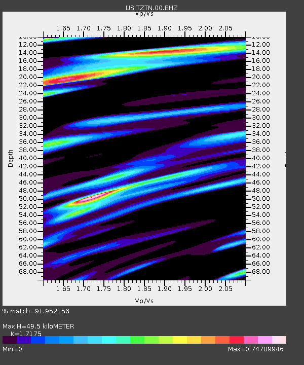
| Estimated Moho Depth: |
49.5 km |
| Estimated Crust Vp/Vs: |
1.72 |
| Assumed Crust Vp: |
6.476 km/s |
| Estimated Crust Vs: |
3.771 km/s |
| Estimated Crust Poisson's Ratio: |
0.24 |
|
| Radial Match: |
91.952156 % |
| Radial Bump: |
400 |
| Transverse Match: |
74.819954 % |
| Transverse Bump: |
400 |
| SOD ConfigId: |
796777 |
| Insert Time: |
2014-10-09 18:37:48.185 +0000 |
| GWidth: |
2.5 |
| Max Bumps: |
400 |
| Tol: |
0.001 |
|

Signal To Noise
| Channel | StoN | STA | LTA |
| US:TZTN:00:BHZ:20140925T17:59:18.348999Z | 5.4351063 | 1.0662294E-6 | 1.9617453E-7 |
| US:TZTN:00:BH1:20140925T17:59:18.348999Z | 3.035397 | 4.1568543E-7 | 1.3694599E-7 |
| US:TZTN:00:BH2:20140925T17:59:18.348999Z | 1.711961 | 2.456845E-7 | 1.4351058E-7 |
| Arrivals |
| Ps | 5.8 SECOND |
| PpPs | 20 SECOND |
| PsPs/PpSs | 25 SECOND |


