You are here: Home > Network List > WI - West Indies IPGP Network Stations List
> Station MAGL Barre de l'ile, Saint louis, Marie Galante > Earthquake Result Viewer
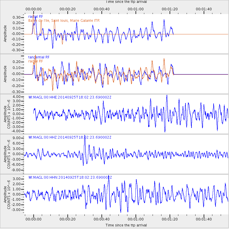
MAGL Barre de l'ile, Saint louis, Marie Galante - Earthquake Result Viewer
*The percent match for this event was below the threshold and hence no stack was calculated.
| Earthquake location: |
Southern Alaska |
| Earthquake latitude/longitude: |
62.0/-151.8 |
| Earthquake time(UTC): |
2014/09/25 (268) 17:51:17 GMT |
| Earthquake Depth: |
103 km |
| Earthquake Magnitude: |
6.2 ML, 6.1 MI, 6.2 MWW, 6.3 MWR, 6.3 MWB, 6.3 MWC |
| Earthquake Catalog/Contributor: |
NEIC PDE/NEIC COMCAT |
|
| Network: |
WI West Indies IPGP Network |
| Station: |
MAGL Barre de l'ile, Saint louis, Marie Galante |
| Lat/Lon: |
15.95 N/61.28 W |
| Elevation: |
150 m |
|
| Distance: |
76.3 deg |
| Az: |
81.923 deg |
| Baz: |
330.892 deg |
| Ray Param: |
$rayparam |
*The percent match for this event was below the threshold and hence was not used in the summary stack. |
|
| Radial Match: |
70.552155 % |
| Radial Bump: |
400 |
| Transverse Match: |
63.158115 % |
| Transverse Bump: |
354 |
| SOD ConfigId: |
796777 |
| Insert Time: |
2014-10-09 18:39:08.210 +0000 |
| GWidth: |
2.5 |
| Max Bumps: |
400 |
| Tol: |
0.001 |
|
Signal To Noise
| Channel | StoN | STA | LTA |
| WI:MAGL:00:HHZ:20140925T18:02:23.690002Z | 2.2232313 | 1.489981E-6 | 6.701871E-7 |
| WI:MAGL:00:HHN:20140925T18:02:23.690002Z | 0.9929605 | 5.3148443E-7 | 5.3525235E-7 |
| WI:MAGL:00:HHE:20140925T18:02:23.690002Z | 1.1334982 | 6.7922457E-7 | 5.992286E-7 |
| Arrivals |
| Ps | |
| PpPs | |
| PsPs/PpSs | |


