You are here: Home > Network List > TA - USArray Transportable Network (new EarthScope stations) Stations List
> Station 121A Cookes Peak, Deming, NM, USA > Earthquake Result Viewer
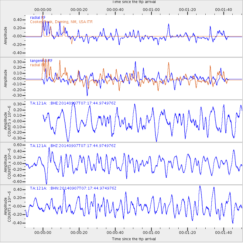
121A Cookes Peak, Deming, NM, USA - Earthquake Result Viewer
*The percent match for this event was below the threshold and hence no stack was calculated.
| Earthquake location: |
Iceland |
| Earthquake latitude/longitude: |
64.5/-17.4 |
| Earthquake time(UTC): |
2014/09/07 (250) 07:07:59 GMT |
| Earthquake Depth: |
5.0 km |
| Earthquake Magnitude: |
5.5 MWW, 5.3 MWB, 5.6 MWC |
| Earthquake Catalog/Contributor: |
NEIC PDE/NEIC COMCAT |
|
| Network: |
TA USArray Transportable Network (new EarthScope stations) |
| Station: |
121A Cookes Peak, Deming, NM, USA |
| Lat/Lon: |
32.53 N/107.79 W |
| Elevation: |
1652 m |
|
| Distance: |
61.3 deg |
| Az: |
285.641 deg |
| Baz: |
29.516 deg |
| Ray Param: |
$rayparam |
*The percent match for this event was below the threshold and hence was not used in the summary stack. |
|
| Radial Match: |
61.91933 % |
| Radial Bump: |
400 |
| Transverse Match: |
55.58204 % |
| Transverse Bump: |
400 |
| SOD ConfigId: |
796777 |
| Insert Time: |
2014-10-12 11:43:39.602 +0000 |
| GWidth: |
2.5 |
| Max Bumps: |
400 |
| Tol: |
0.001 |
|
Signal To Noise
| Channel | StoN | STA | LTA |
| TA:121A: :BHZ:20140907T07:17:44.974976Z | 2.358143 | 3.164864E-7 | 1.3421E-7 |
| TA:121A: :BHN:20140907T07:17:44.974976Z | 0.54788053 | 8.281966E-8 | 1.5116372E-7 |
| TA:121A: :BHE:20140907T07:17:44.974976Z | 0.49513263 | 7.6490686E-8 | 1.5448525E-7 |
| Arrivals |
| Ps | |
| PpPs | |
| PsPs/PpSs | |


