You are here: Home > Network List > TA - USArray Transportable Network (new EarthScope stations) Stations List
> Station M51A Elyria, OH, USA > Earthquake Result Viewer
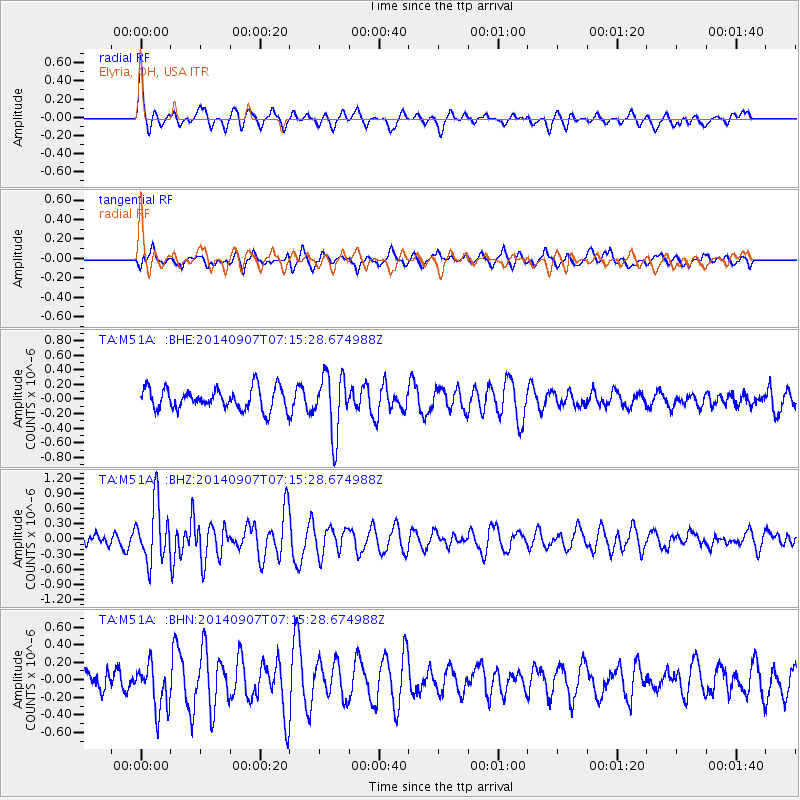
M51A Elyria, OH, USA - Earthquake Result Viewer
*The percent match for this event was below the threshold and hence no stack was calculated.
| Earthquake location: |
Iceland |
| Earthquake latitude/longitude: |
64.5/-17.4 |
| Earthquake time(UTC): |
2014/09/07 (250) 07:07:59 GMT |
| Earthquake Depth: |
5.0 km |
| Earthquake Magnitude: |
5.5 MWW, 5.3 MWB, 5.6 MWC |
| Earthquake Catalog/Contributor: |
NEIC PDE/NEIC COMCAT |
|
| Network: |
TA USArray Transportable Network (new EarthScope stations) |
| Station: |
M51A Elyria, OH, USA |
| Lat/Lon: |
41.33 N/82.18 W |
| Elevation: |
239 m |
|
| Distance: |
43.0 deg |
| Az: |
269.584 deg |
| Baz: |
35.019 deg |
| Ray Param: |
$rayparam |
*The percent match for this event was below the threshold and hence was not used in the summary stack. |
|
| Radial Match: |
78.29286 % |
| Radial Bump: |
400 |
| Transverse Match: |
51.70698 % |
| Transverse Bump: |
400 |
| SOD ConfigId: |
796777 |
| Insert Time: |
2014-10-12 11:47:53.550 +0000 |
| GWidth: |
2.5 |
| Max Bumps: |
400 |
| Tol: |
0.001 |
|
Signal To Noise
| Channel | StoN | STA | LTA |
| TA:M51A: :BHZ:20140907T07:15:28.674988Z | 4.110951 | 5.76583E-7 | 1.4025538E-7 |
| TA:M51A: :BHN:20140907T07:15:28.674988Z | 1.6014578 | 2.620427E-7 | 1.636276E-7 |
| TA:M51A: :BHE:20140907T07:15:28.674988Z | 2.8041425 | 4.0836574E-7 | 1.4562944E-7 |
| Arrivals |
| Ps | |
| PpPs | |
| PsPs/PpSs | |


