You are here: Home > Network List > TA - USArray Transportable Network (new EarthScope stations) Stations List
> Station T59A Double 'B' Farms, VA, USA > Earthquake Result Viewer
T59A Double 'B' Farms, VA, USA - Earthquake Result Viewer
| Earthquake location: |
Iceland |
| Earthquake latitude/longitude: |
64.5/-17.4 |
| Earthquake time(UTC): |
2014/09/07 (250) 07:07:59 GMT |
| Earthquake Depth: |
5.0 km |
| Earthquake Magnitude: |
5.5 MWW, 5.3 MWB, 5.6 MWC |
| Earthquake Catalog/Contributor: |
NEIC PDE/NEIC COMCAT |
|
| Network: |
TA USArray Transportable Network (new EarthScope stations) |
| Station: |
T59A Double 'B' Farms, VA, USA |
| Lat/Lon: |
36.97 N/77.55 W |
| Elevation: |
63 m |
|
| Distance: |
44.6 deg |
| Az: |
261.763 deg |
| Baz: |
32.28 deg |
| Ray Param: |
0.07184091 |
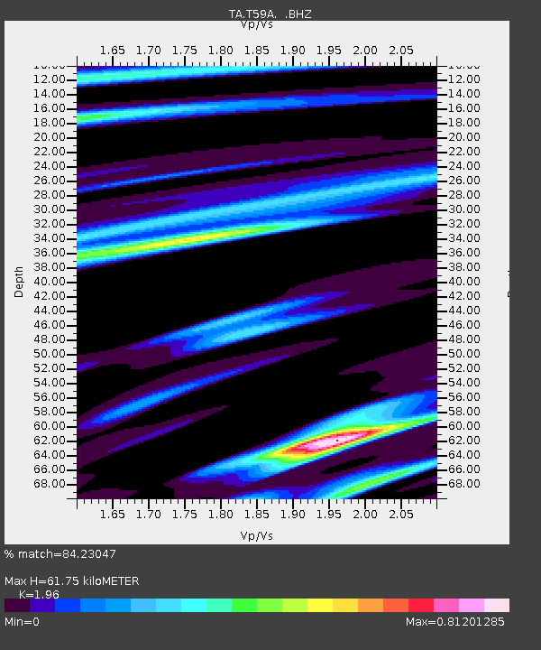
| Estimated Moho Depth: |
61.75 km |
| Estimated Crust Vp/Vs: |
1.96 |
| Assumed Crust Vp: |
6.565 km/s |
| Estimated Crust Vs: |
3.349 km/s |
| Estimated Crust Poisson's Ratio: |
0.32 |
|
| Radial Match: |
84.23047 % |
| Radial Bump: |
400 |
| Transverse Match: |
60.2182 % |
| Transverse Bump: |
400 |
| SOD ConfigId: |
796777 |
| Insert Time: |
2014-10-12 11:51:20.591 +0000 |
| GWidth: |
2.5 |
| Max Bumps: |
400 |
| Tol: |
0.001 |
|

Signal To Noise
| Channel | StoN | STA | LTA |
| TA:T59A: :BHZ:20140907T07:15:41.750Z | 4.9481955 | 3.9866165E-7 | 8.056708E-8 |
| TA:T59A: :BHN:20140907T07:15:41.750Z | 3.1139104 | 2.0755394E-7 | 6.665379E-8 |
| TA:T59A: :BHE:20140907T07:15:41.750Z | 1.3448652 | 9.374609E-8 | 6.970668E-8 |
| Arrivals |
| Ps | 9.6 SECOND |
| PpPs | 26 SECOND |
| PsPs/PpSs | 36 SECOND |


