You are here: Home > Network List > TA - USArray Transportable Network (new EarthScope stations) Stations List
> Station Z41A Richland Creek Farm, El Dorado, AR, USA > Earthquake Result Viewer
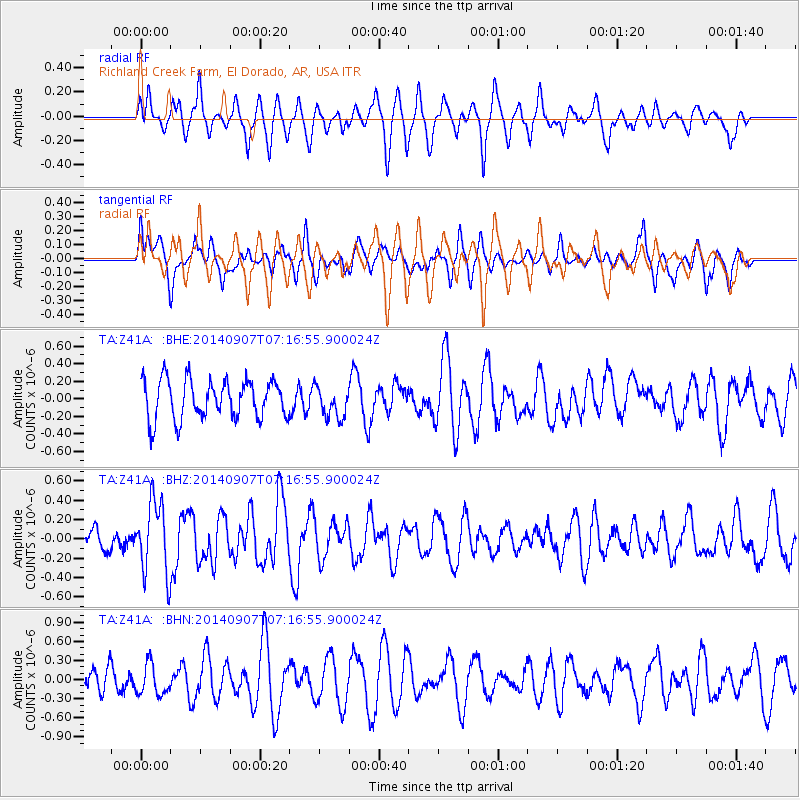
Z41A Richland Creek Farm, El Dorado, AR, USA - Earthquake Result Viewer
*The percent match for this event was below the threshold and hence no stack was calculated.
| Earthquake location: |
Iceland |
| Earthquake latitude/longitude: |
64.5/-17.4 |
| Earthquake time(UTC): |
2014/09/07 (250) 07:07:59 GMT |
| Earthquake Depth: |
5.0 km |
| Earthquake Magnitude: |
5.5 MWW, 5.3 MWB, 5.6 MWC |
| Earthquake Catalog/Contributor: |
NEIC PDE/NEIC COMCAT |
|
| Network: |
TA USArray Transportable Network (new EarthScope stations) |
| Station: |
Z41A Richland Creek Farm, El Dorado, AR, USA |
| Lat/Lon: |
33.26 N/92.80 W |
| Elevation: |
62 m |
|
| Distance: |
54.3 deg |
| Az: |
273.214 deg |
| Baz: |
30.996 deg |
| Ray Param: |
$rayparam |
*The percent match for this event was below the threshold and hence was not used in the summary stack. |
|
| Radial Match: |
61.974316 % |
| Radial Bump: |
400 |
| Transverse Match: |
54.247887 % |
| Transverse Bump: |
400 |
| SOD ConfigId: |
796777 |
| Insert Time: |
2014-10-12 11:53:10.681 +0000 |
| GWidth: |
2.5 |
| Max Bumps: |
400 |
| Tol: |
0.001 |
|
Signal To Noise
| Channel | StoN | STA | LTA |
| TA:Z41A: :BHZ:20140907T07:16:55.900024Z | 2.9734783 | 3.744202E-7 | 1.2591994E-7 |
| TA:Z41A: :BHN:20140907T07:16:55.900024Z | 0.9367568 | 2.4239694E-7 | 2.5876187E-7 |
| TA:Z41A: :BHE:20140907T07:16:55.900024Z | 0.7988672 | 1.771859E-7 | 2.2179643E-7 |
| Arrivals |
| Ps | |
| PpPs | |
| PsPs/PpSs | |


