You are here: Home > Network List > AK - Alaska Regional Network Stations List
> Station WAT7 Susitna Watana 7, AK, USA > Earthquake Result Viewer
WAT7 Susitna Watana 7, AK, USA - Earthquake Result Viewer
| Earthquake location: |
New Britain Region, P.N.G. |
| Earthquake latitude/longitude: |
-5.5/151.8 |
| Earthquake time(UTC): |
2015/04/30 (120) 10:45:06 GMT |
| Earthquake Depth: |
60 km |
| Earthquake Magnitude: |
6.8 MWP, 6.8 MI |
| Earthquake Catalog/Contributor: |
NEIC PDE/NEIC COMCAT |
|
| Network: |
AK Alaska Regional Network |
| Station: |
WAT7 Susitna Watana 7, AK, USA |
| Lat/Lon: |
62.83 N/148.85 W |
| Elevation: |
1232 m |
|
| Distance: |
81.4 deg |
| Az: |
23.532 deg |
| Baz: |
239.991 deg |
| Ray Param: |
0.04748351 |
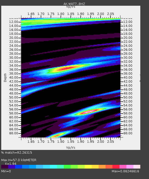
| Estimated Moho Depth: |
57.0 km |
| Estimated Crust Vp/Vs: |
1.94 |
| Assumed Crust Vp: |
6.566 km/s |
| Estimated Crust Vs: |
3.385 km/s |
| Estimated Crust Poisson's Ratio: |
0.32 |
|
| Radial Match: |
92.26315 % |
| Radial Bump: |
357 |
| Transverse Match: |
76.246704 % |
| Transverse Bump: |
400 |
| SOD ConfigId: |
7422571 |
| Insert Time: |
2019-04-18 14:43:55.851 +0000 |
| GWidth: |
2.5 |
| Max Bumps: |
400 |
| Tol: |
0.001 |
|

Signal To Noise
| Channel | StoN | STA | LTA |
| AK:WAT7: :BHZ:20150430T10:56:44.807988Z | 20.032146 | 3.0215463E-6 | 1.5083488E-7 |
| AK:WAT7: :BHN:20150430T10:56:44.807988Z | 4.651929 | 5.3331195E-7 | 1.1464319E-7 |
| AK:WAT7: :BHE:20150430T10:56:44.807988Z | 8.933602 | 1.0661223E-6 | 1.1933845E-7 |
| Arrivals |
| Ps | 8.4 SECOND |
| PpPs | 25 SECOND |
| PsPs/PpSs | 33 SECOND |


