You are here: Home > Network List > AU - Australian Seismological Centre Stations List
> Station XMIS Christmas Island Grants Well > Earthquake Result Viewer
XMIS Christmas Island Grants Well - Earthquake Result Viewer
| Earthquake location: |
New Britain Region, P.N.G. |
| Earthquake latitude/longitude: |
-5.5/151.8 |
| Earthquake time(UTC): |
2015/04/30 (120) 10:45:06 GMT |
| Earthquake Depth: |
60 km |
| Earthquake Magnitude: |
6.8 MWP, 6.8 MI |
| Earthquake Catalog/Contributor: |
NEIC PDE/NEIC COMCAT |
|
| Network: |
AU Australian Seismological Centre |
| Station: |
XMIS Christmas Island Grants Well |
| Lat/Lon: |
10.48 S/105.65 E |
| Elevation: |
210 m |
|
| Distance: |
46.0 deg |
| Az: |
260.747 deg |
| Baz: |
87.473 deg |
| Ray Param: |
0.07077069 |
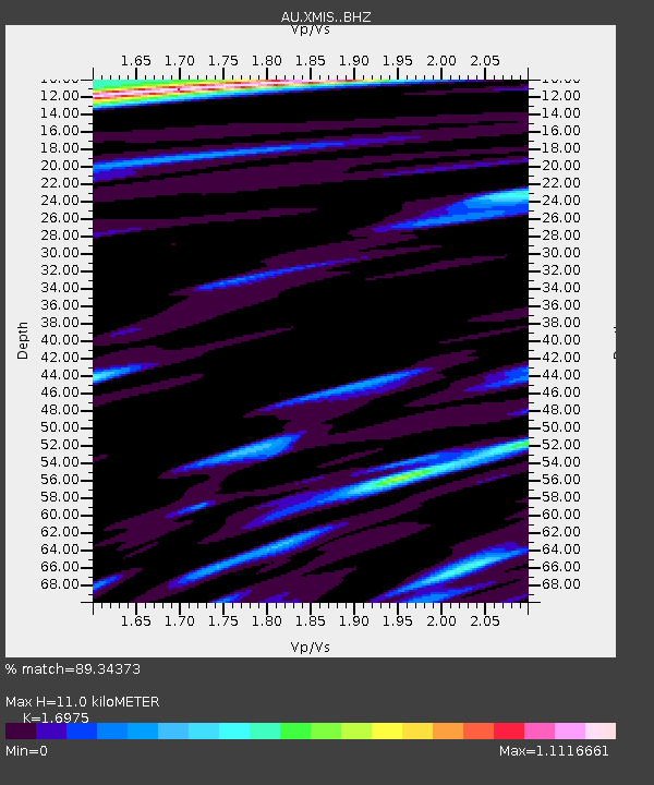
| Estimated Moho Depth: |
11.0 km |
| Estimated Crust Vp/Vs: |
1.70 |
| Assumed Crust Vp: |
4.157 km/s |
| Estimated Crust Vs: |
2.449 km/s |
| Estimated Crust Poisson's Ratio: |
0.23 |
|
| Radial Match: |
89.34373 % |
| Radial Bump: |
351 |
| Transverse Match: |
66.07222 % |
| Transverse Bump: |
400 |
| SOD ConfigId: |
7422571 |
| Insert Time: |
2019-04-18 14:44:17.170 +0000 |
| GWidth: |
2.5 |
| Max Bumps: |
400 |
| Tol: |
0.001 |
|

Signal To Noise
| Channel | StoN | STA | LTA |
| AU:XMIS: :BHZ:20150430T10:52:52.343999Z | 4.1805396 | 4.3654104E-6 | 1.0442217E-6 |
| AU:XMIS: :BHN:20150430T10:52:52.343999Z | 0.894223 | 1.0345545E-6 | 1.1569313E-6 |
| AU:XMIS: :BHE:20150430T10:52:52.343999Z | 3.4364812 | 2.9719195E-6 | 8.648147E-7 |
| Arrivals |
| Ps | 1.9 SECOND |
| PpPs | 7.0 SECOND |
| PsPs/PpSs | 8.8 SECOND |


