You are here: Home > Network List > AV - Alaska Volcano Observatory Stations List
> Station SPCR Ckakachatna River, Mount Spurr, Alaska > Earthquake Result Viewer
SPCR Ckakachatna River, Mount Spurr, Alaska - Earthquake Result Viewer
| Earthquake location: |
New Britain Region, P.N.G. |
| Earthquake latitude/longitude: |
-5.5/151.8 |
| Earthquake time(UTC): |
2015/04/30 (120) 10:45:06 GMT |
| Earthquake Depth: |
60 km |
| Earthquake Magnitude: |
6.8 MWP, 6.8 MI |
| Earthquake Catalog/Contributor: |
NEIC PDE/NEIC COMCAT |
|
| Network: |
AV Alaska Volcano Observatory |
| Station: |
SPCR Ckakachatna River, Mount Spurr, Alaska |
| Lat/Lon: |
61.20 N/152.21 W |
| Elevation: |
984 m |
|
| Distance: |
79.2 deg |
| Az: |
24.111 deg |
| Baz: |
237.124 deg |
| Ray Param: |
0.048998147 |
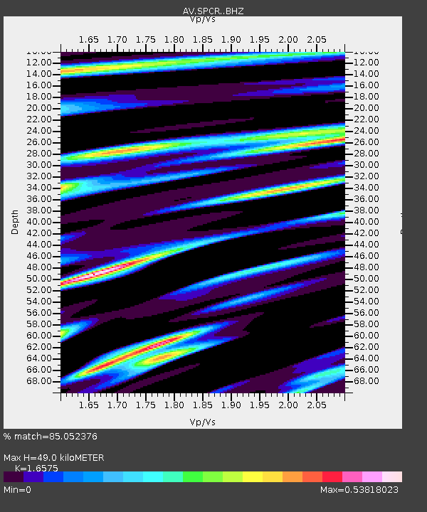
| Estimated Moho Depth: |
49.0 km |
| Estimated Crust Vp/Vs: |
1.66 |
| Assumed Crust Vp: |
6.566 km/s |
| Estimated Crust Vs: |
3.961 km/s |
| Estimated Crust Poisson's Ratio: |
0.21 |
|
| Radial Match: |
85.052376 % |
| Radial Bump: |
400 |
| Transverse Match: |
60.73287 % |
| Transverse Bump: |
400 |
| SOD ConfigId: |
7422571 |
| Insert Time: |
2019-04-18 14:44:32.311 +0000 |
| GWidth: |
2.5 |
| Max Bumps: |
400 |
| Tol: |
0.001 |
|
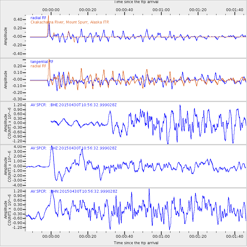
Signal To Noise
| Channel | StoN | STA | LTA |
| AV:SPCR: :BHZ:20150430T10:56:32.999028Z | 19.635323 | 2.465733E-6 | 1.2557639E-7 |
| AV:SPCR: :BHN:20150430T10:56:32.999028Z | 2.254742 | 7.335025E-7 | 3.2531548E-7 |
| AV:SPCR: :BHE:20150430T10:56:32.999028Z | 3.3225992 | 4.2936998E-7 | 1.2922713E-7 |
| Arrivals |
| Ps | 5.1 SECOND |
| PpPs | 19 SECOND |
| PsPs/PpSs | 24 SECOND |


