You are here: Home > Network List > ZW13 - Locating North Texas Earthquakes Stations List
> Station AZWR Azle B4 > Earthquake Result Viewer
AZWR Azle B4 - Earthquake Result Viewer
| Earthquake location: |
Fiji Islands Region |
| Earthquake latitude/longitude: |
-17.8/-178.6 |
| Earthquake time(UTC): |
2014/09/30 (273) 22:34:27 GMT |
| Earthquake Depth: |
574 km |
| Earthquake Magnitude: |
5.5 MWP |
| Earthquake Catalog/Contributor: |
NEIC PDE/NEIC COMCAT |
|
| Network: |
ZW Locating North Texas Earthquakes |
| Station: |
AZWR Azle B4 |
| Lat/Lon: |
32.81 N/98.31 W |
| Elevation: |
381 m |
|
| Distance: |
91.6 deg |
| Az: |
56.137 deg |
| Baz: |
249.945 deg |
| Ray Param: |
0.04118712 |
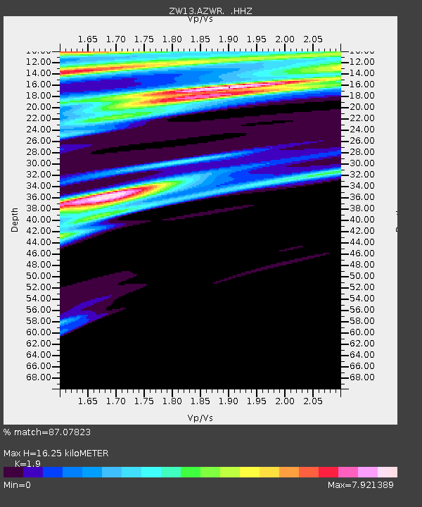
| Estimated Moho Depth: |
16.25 km |
| Estimated Crust Vp/Vs: |
1.90 |
| Assumed Crust Vp: |
6.426 km/s |
| Estimated Crust Vs: |
3.382 km/s |
| Estimated Crust Poisson's Ratio: |
0.31 |
|
| Radial Match: |
87.07823 % |
| Radial Bump: |
400 |
| Transverse Match: |
86.60841 % |
| Transverse Bump: |
400 |
| SOD ConfigId: |
796777 |
| Insert Time: |
2014-10-14 23:15:19.355 +0000 |
| GWidth: |
2.5 |
| Max Bumps: |
400 |
| Tol: |
0.001 |
|

Signal To Noise
| Channel | StoN | STA | LTA |
| ZW:AZWR: :HHZ:20140930T22:46:02.249976Z | 2.462985 | 3.0998626E-7 | 1.2585795E-7 |
| ZW:AZWR: :HHN:20140930T22:46:02.249976Z | 0.3247487 | 2.7384558E-6 | 8.432538E-6 |
| ZW:AZWR: :HHE:20140930T22:46:02.249976Z | 3.3582683 | 2.616512E-6 | 7.7912534E-7 |
| Arrivals |
| Ps | 2.3 SECOND |
| PpPs | 7.2 SECOND |
| PsPs/PpSs | 9.5 SECOND |


