You are here: Home > Network List > PS - Pacific21 Stations List
> Station PSI Parapat, Indonesia > Earthquake Result Viewer
PSI Parapat, Indonesia - Earthquake Result Viewer
| Earthquake location: |
New Britain Region, P.N.G. |
| Earthquake latitude/longitude: |
-5.5/151.8 |
| Earthquake time(UTC): |
2015/04/30 (120) 10:45:06 GMT |
| Earthquake Depth: |
60 km |
| Earthquake Magnitude: |
6.8 MWP, 6.8 MI |
| Earthquake Catalog/Contributor: |
NEIC PDE/NEIC COMCAT |
|
| Network: |
PS Pacific21 |
| Station: |
PSI Parapat, Indonesia |
| Lat/Lon: |
2.69 N/98.92 E |
| Elevation: |
987 m |
|
| Distance: |
53.5 deg |
| Az: |
277.394 deg |
| Baz: |
98.762 deg |
| Ray Param: |
0.06592329 |
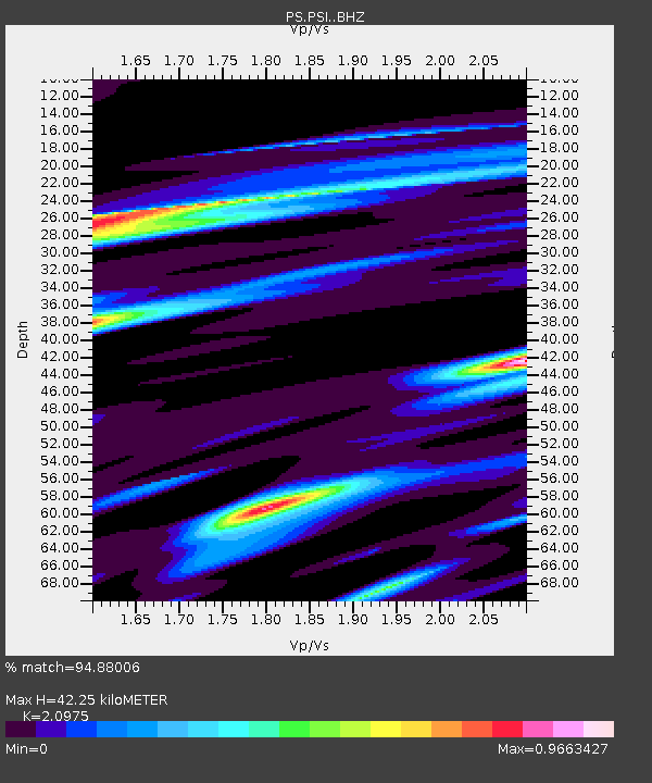
| Estimated Moho Depth: |
42.25 km |
| Estimated Crust Vp/Vs: |
2.10 |
| Assumed Crust Vp: |
6.468 km/s |
| Estimated Crust Vs: |
3.084 km/s |
| Estimated Crust Poisson's Ratio: |
0.35 |
|
| Radial Match: |
94.88006 % |
| Radial Bump: |
400 |
| Transverse Match: |
88.052795 % |
| Transverse Bump: |
400 |
| SOD ConfigId: |
7422571 |
| Insert Time: |
2019-04-18 14:48:08.958 +0000 |
| GWidth: |
2.5 |
| Max Bumps: |
400 |
| Tol: |
0.001 |
|
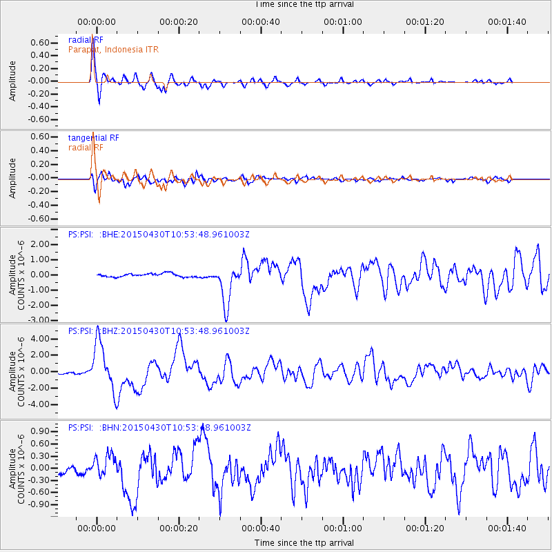
Signal To Noise
| Channel | StoN | STA | LTA |
| PS:PSI: :BHZ:20150430T10:53:48.961003Z | 32.664997 | 3.1086388E-6 | 9.516727E-8 |
| PS:PSI: :BHN:20150430T10:53:48.961003Z | 2.6533227 | 2.613831E-7 | 9.851161E-8 |
| PS:PSI: :BHE:20150430T10:53:48.961003Z | 12.538757 | 1.4459505E-6 | 1.15318485E-7 |
| Arrivals |
| Ps | 7.5 SECOND |
| PpPs | 19 SECOND |
| PsPs/PpSs | 27 SECOND |


