You are here: Home > Network List > S - Seismographs in Schools Projects Stations List
> Station AUUHS Ulladulla High School, Ulladulla, NSW > Earthquake Result Viewer
AUUHS Ulladulla High School, Ulladulla, NSW - Earthquake Result Viewer
| Earthquake location: |
New Britain Region, P.N.G. |
| Earthquake latitude/longitude: |
-5.5/151.8 |
| Earthquake time(UTC): |
2015/04/30 (120) 10:45:06 GMT |
| Earthquake Depth: |
60 km |
| Earthquake Magnitude: |
6.8 MWP, 6.8 MI |
| Earthquake Catalog/Contributor: |
NEIC PDE/NEIC COMCAT |
|
| Network: |
S Seismographs in Schools Projects |
| Station: |
AUUHS Ulladulla High School, Ulladulla, NSW |
| Lat/Lon: |
35.36 S/150.47 E |
| Elevation: |
44 m |
|
| Distance: |
29.8 deg |
| Az: |
182.229 deg |
| Baz: |
2.715 deg |
| Ray Param: |
0.07941975 |
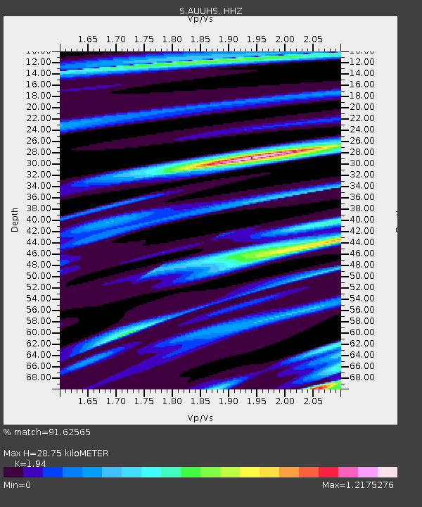
| Estimated Moho Depth: |
28.75 km |
| Estimated Crust Vp/Vs: |
1.94 |
| Assumed Crust Vp: |
6.472 km/s |
| Estimated Crust Vs: |
3.336 km/s |
| Estimated Crust Poisson's Ratio: |
0.32 |
|
| Radial Match: |
91.62565 % |
| Radial Bump: |
400 |
| Transverse Match: |
73.63566 % |
| Transverse Bump: |
400 |
| SOD ConfigId: |
7422571 |
| Insert Time: |
2019-04-18 14:48:34.227 +0000 |
| GWidth: |
2.5 |
| Max Bumps: |
400 |
| Tol: |
0.001 |
|

Signal To Noise
| Channel | StoN | STA | LTA |
| S:AUUHS: :HHZ:20150430T10:50:37.500005Z | 3.4678762 | 1.4344695E-6 | 4.1364493E-7 |
| S:AUUHS: :HHN:20150430T10:50:37.500005Z | 2.5105867 | 1.103025E-6 | 4.3934952E-7 |
| S:AUUHS: :HHE:20150430T10:50:37.500005Z | 1.0170372 | 4.6753445E-7 | 4.5970245E-7 |
| Arrivals |
| Ps | 4.5 SECOND |
| PpPs | 12 SECOND |
| PsPs/PpSs | 17 SECOND |


