You are here: Home > Network List > UW - Pacific Northwest Regional Seismic Network Stations List
> Station PASS Maple Falls, WA, USA > Earthquake Result Viewer
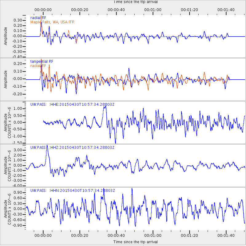
PASS Maple Falls, WA, USA - Earthquake Result Viewer
*The percent match for this event was below the threshold and hence no stack was calculated.
| Earthquake location: |
New Britain Region, P.N.G. |
| Earthquake latitude/longitude: |
-5.5/151.8 |
| Earthquake time(UTC): |
2015/04/30 (120) 10:45:06 GMT |
| Earthquake Depth: |
60 km |
| Earthquake Magnitude: |
6.8 MWP, 6.8 MI |
| Earthquake Catalog/Contributor: |
NEIC PDE/NEIC COMCAT |
|
| Network: |
UW Pacific Northwest Regional Seismic Network |
| Station: |
PASS Maple Falls, WA, USA |
| Lat/Lon: |
49.00 N/122.09 W |
| Elevation: |
174 m |
|
| Distance: |
91.5 deg |
| Az: |
41.093 deg |
| Baz: |
263.493 deg |
| Ray Param: |
$rayparam |
*The percent match for this event was below the threshold and hence was not used in the summary stack. |
|
| Radial Match: |
70.77126 % |
| Radial Bump: |
400 |
| Transverse Match: |
56.23835 % |
| Transverse Bump: |
400 |
| SOD ConfigId: |
7422571 |
| Insert Time: |
2019-04-18 14:50:13.371 +0000 |
| GWidth: |
2.5 |
| Max Bumps: |
400 |
| Tol: |
0.001 |
|
Signal To Noise
| Channel | StoN | STA | LTA |
| UW:PASS: :HHZ:20150430T10:57:34.28803Z | 4.480232 | 1.749311E-6 | 3.9045102E-7 |
| UW:PASS: :HHN:20150430T10:57:34.28803Z | 0.8706432 | 2.6755703E-7 | 3.0730962E-7 |
| UW:PASS: :HHE:20150430T10:57:34.28803Z | 3.6152382 | 6.4514904E-7 | 1.7845271E-7 |
| Arrivals |
| Ps | |
| PpPs | |
| PsPs/PpSs | |


