You are here: Home > Network List > TA - USArray Transportable Network (new EarthScope stations) Stations List
> Station H17A Grant Village (NPS), Yellowstone Nt. Park, WY, USA > Earthquake Result Viewer
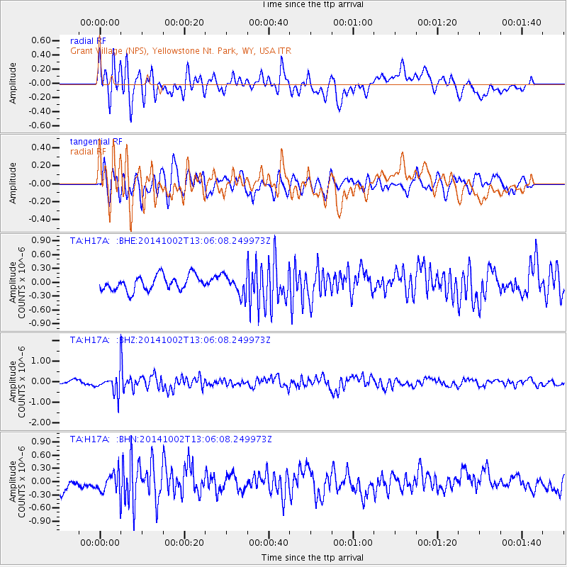
H17A Grant Village (NPS), Yellowstone Nt. Park, WY, USA - Earthquake Result Viewer
*The percent match for this event was below the threshold and hence no stack was calculated.
| Earthquake location: |
Kamchatka Peninsula, Russia |
| Earthquake latitude/longitude: |
52.4/158.0 |
| Earthquake time(UTC): |
2014/10/02 (275) 12:57:06 GMT |
| Earthquake Depth: |
150 km |
| Earthquake Magnitude: |
5.7 MB |
| Earthquake Catalog/Contributor: |
NEIC PDE/NEIC COMCAT |
|
| Network: |
TA USArray Transportable Network (new EarthScope stations) |
| Station: |
H17A Grant Village (NPS), Yellowstone Nt. Park, WY, USA |
| Lat/Lon: |
44.40 N/110.58 W |
| Elevation: |
2400 m |
|
| Distance: |
57.3 deg |
| Az: |
58.358 deg |
| Baz: |
313.283 deg |
| Ray Param: |
$rayparam |
*The percent match for this event was below the threshold and hence was not used in the summary stack. |
|
| Radial Match: |
65.13296 % |
| Radial Bump: |
400 |
| Transverse Match: |
52.05435 % |
| Transverse Bump: |
400 |
| SOD ConfigId: |
796777 |
| Insert Time: |
2014-10-16 13:45:14.589 +0000 |
| GWidth: |
2.5 |
| Max Bumps: |
400 |
| Tol: |
0.001 |
|
Signal To Noise
| Channel | StoN | STA | LTA |
| TA:H17A: :BHZ:20141002T13:06:08.249973Z | 4.142242 | 4.9636424E-7 | 1.1982985E-7 |
| TA:H17A: :BHN:20141002T13:06:08.249973Z | 1.7543204 | 2.3643086E-7 | 1.3477063E-7 |
| TA:H17A: :BHE:20141002T13:06:08.249973Z | 1.3336722 | 2.1558036E-7 | 1.616442E-7 |
| Arrivals |
| Ps | |
| PpPs | |
| PsPs/PpSs | |


