You are here: Home > Network List > TA - USArray Transportable Network (new EarthScope stations) Stations List
> Station J01E Myrtle Point, OR, USA > Earthquake Result Viewer
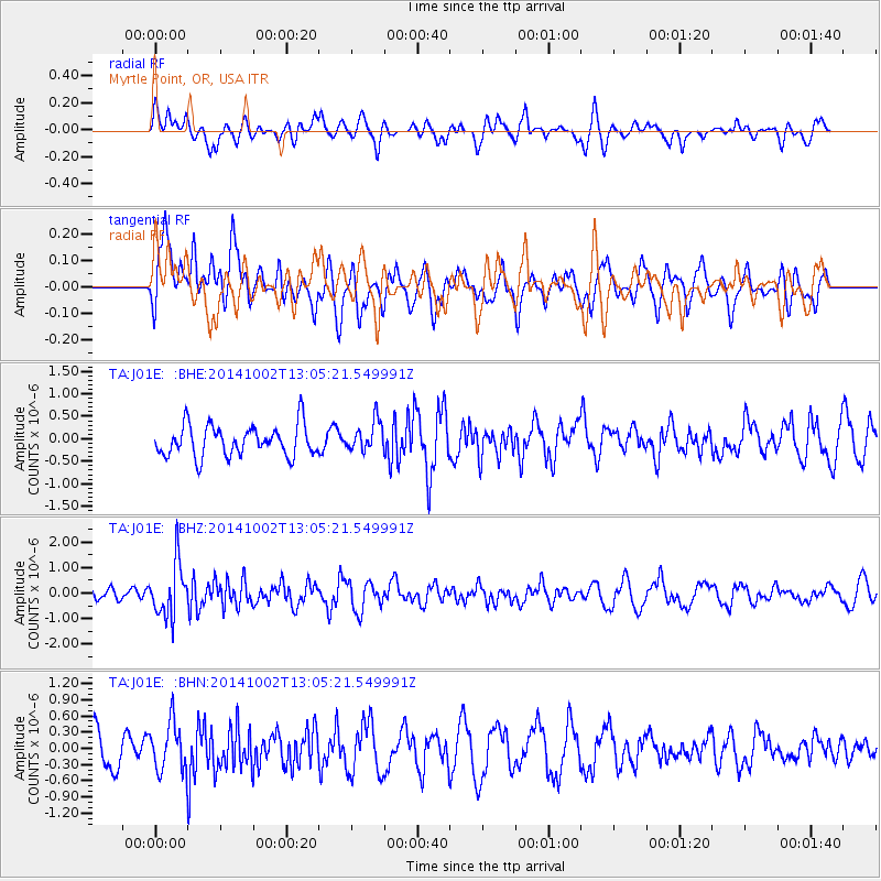
J01E Myrtle Point, OR, USA - Earthquake Result Viewer
*The percent match for this event was below the threshold and hence no stack was calculated.
| Earthquake location: |
Kamchatka Peninsula, Russia |
| Earthquake latitude/longitude: |
52.4/158.0 |
| Earthquake time(UTC): |
2014/10/02 (275) 12:57:06 GMT |
| Earthquake Depth: |
150 km |
| Earthquake Magnitude: |
5.7 MB |
| Earthquake Catalog/Contributor: |
NEIC PDE/NEIC COMCAT |
|
| Network: |
TA USArray Transportable Network (new EarthScope stations) |
| Station: |
J01E Myrtle Point, OR, USA |
| Lat/Lon: |
43.16 N/123.93 W |
| Elevation: |
128 m |
|
| Distance: |
50.9 deg |
| Az: |
67.37 deg |
| Baz: |
309.353 deg |
| Ray Param: |
$rayparam |
*The percent match for this event was below the threshold and hence was not used in the summary stack. |
|
| Radial Match: |
51.76145 % |
| Radial Bump: |
400 |
| Transverse Match: |
62.588184 % |
| Transverse Bump: |
400 |
| SOD ConfigId: |
796777 |
| Insert Time: |
2014-10-16 13:45:52.427 +0000 |
| GWidth: |
2.5 |
| Max Bumps: |
400 |
| Tol: |
0.001 |
|
Signal To Noise
| Channel | StoN | STA | LTA |
| TA:J01E: :BHZ:20141002T13:05:21.549991Z | 3.7699616 | 1.0290815E-6 | 2.7296872E-7 |
| TA:J01E: :BHN:20141002T13:05:21.549991Z | 1.7454766 | 4.3670565E-7 | 2.5019278E-7 |
| TA:J01E: :BHE:20141002T13:05:21.549991Z | 0.9707598 | 3.3182044E-7 | 3.418152E-7 |
| Arrivals |
| Ps | |
| PpPs | |
| PsPs/PpSs | |


