You are here: Home > Network List > US - United States National Seismic Network Stations List
> Station AMTX Amarillo, Texas, USA > Earthquake Result Viewer
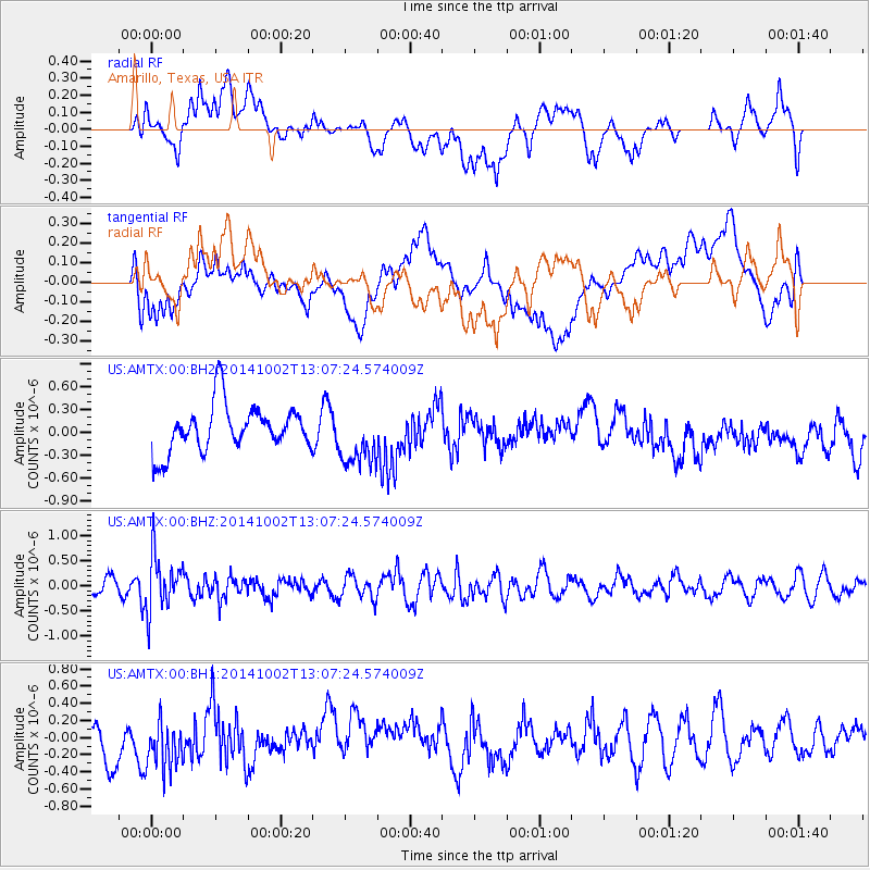
AMTX Amarillo, Texas, USA - Earthquake Result Viewer
*The percent match for this event was below the threshold and hence no stack was calculated.
| Earthquake location: |
Kamchatka Peninsula, Russia |
| Earthquake latitude/longitude: |
52.4/158.0 |
| Earthquake time(UTC): |
2014/10/02 (275) 12:57:06 GMT |
| Earthquake Depth: |
150 km |
| Earthquake Magnitude: |
5.7 MB |
| Earthquake Catalog/Contributor: |
NEIC PDE/NEIC COMCAT |
|
| Network: |
US United States National Seismic Network |
| Station: |
AMTX Amarillo, Texas, USA |
| Lat/Lon: |
34.53 N/101.41 W |
| Elevation: |
1010 m |
|
| Distance: |
69.4 deg |
| Az: |
60.136 deg |
| Baz: |
319.917 deg |
| Ray Param: |
$rayparam |
*The percent match for this event was below the threshold and hence was not used in the summary stack. |
|
| Radial Match: |
36.99708 % |
| Radial Bump: |
400 |
| Transverse Match: |
32.14064 % |
| Transverse Bump: |
400 |
| SOD ConfigId: |
796777 |
| Insert Time: |
2014-10-16 13:51:48.669 +0000 |
| GWidth: |
2.5 |
| Max Bumps: |
400 |
| Tol: |
0.001 |
|
Signal To Noise
| Channel | StoN | STA | LTA |
| US:AMTX:00:BHZ:20141002T13:07:24.574009Z | 3.1985714 | 5.415471E-7 | 1.6930906E-7 |
| US:AMTX:00:BH1:20141002T13:07:24.574009Z | 1.5848191 | 3.409149E-7 | 2.1511283E-7 |
| US:AMTX:00:BH2:20141002T13:07:24.574009Z | 1.8154359 | 4.9284995E-7 | 2.7147746E-7 |
| Arrivals |
| Ps | |
| PpPs | |
| PsPs/PpSs | |


