You are here: Home > Network List > US - United States National Seismic Network Stations List
> Station LAO LASA Array, Montana, USA > Earthquake Result Viewer
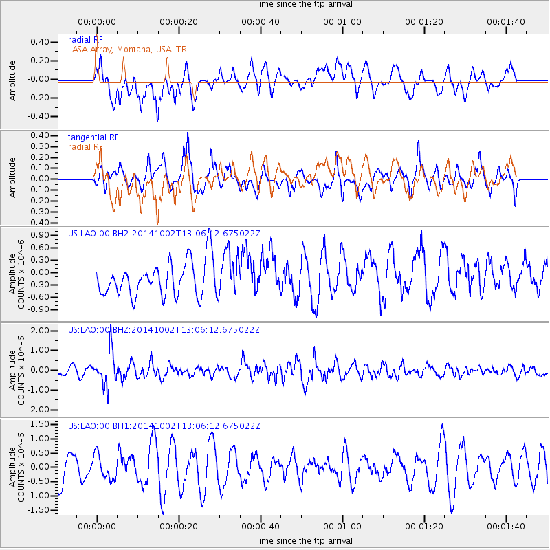
LAO LASA Array, Montana, USA - Earthquake Result Viewer
*The percent match for this event was below the threshold and hence no stack was calculated.
| Earthquake location: |
Kamchatka Peninsula, Russia |
| Earthquake latitude/longitude: |
52.4/158.0 |
| Earthquake time(UTC): |
2014/10/02 (275) 12:57:06 GMT |
| Earthquake Depth: |
150 km |
| Earthquake Magnitude: |
5.7 MB |
| Earthquake Catalog/Contributor: |
NEIC PDE/NEIC COMCAT |
|
| Network: |
US United States National Seismic Network |
| Station: |
LAO LASA Array, Montana, USA |
| Lat/Lon: |
46.69 N/106.22 W |
| Elevation: |
902 m |
|
| Distance: |
58.0 deg |
| Az: |
53.895 deg |
| Baz: |
313.991 deg |
| Ray Param: |
$rayparam |
*The percent match for this event was below the threshold and hence was not used in the summary stack. |
|
| Radial Match: |
48.13396 % |
| Radial Bump: |
400 |
| Transverse Match: |
39.70682 % |
| Transverse Bump: |
345 |
| SOD ConfigId: |
796777 |
| Insert Time: |
2014-10-16 13:52:58.834 +0000 |
| GWidth: |
2.5 |
| Max Bumps: |
400 |
| Tol: |
0.001 |
|
Signal To Noise
| Channel | StoN | STA | LTA |
| US:LAO:00:BHZ:20141002T13:06:12.675022Z | 4.0199904 | 8.517773E-7 | 2.118854E-7 |
| US:LAO:00:BH1:20141002T13:06:12.675022Z | 0.79711753 | 4.3260553E-7 | 5.4271237E-7 |
| US:LAO:00:BH2:20141002T13:06:12.675022Z | 1.6232451 | 5.409619E-7 | 3.3325952E-7 |
| Arrivals |
| Ps | |
| PpPs | |
| PsPs/PpSs | |


