You are here: Home > Network List > US - United States National Seismic Network Stations List
> Station MNTX Cornudas Mountains, Texas, USA > Earthquake Result Viewer
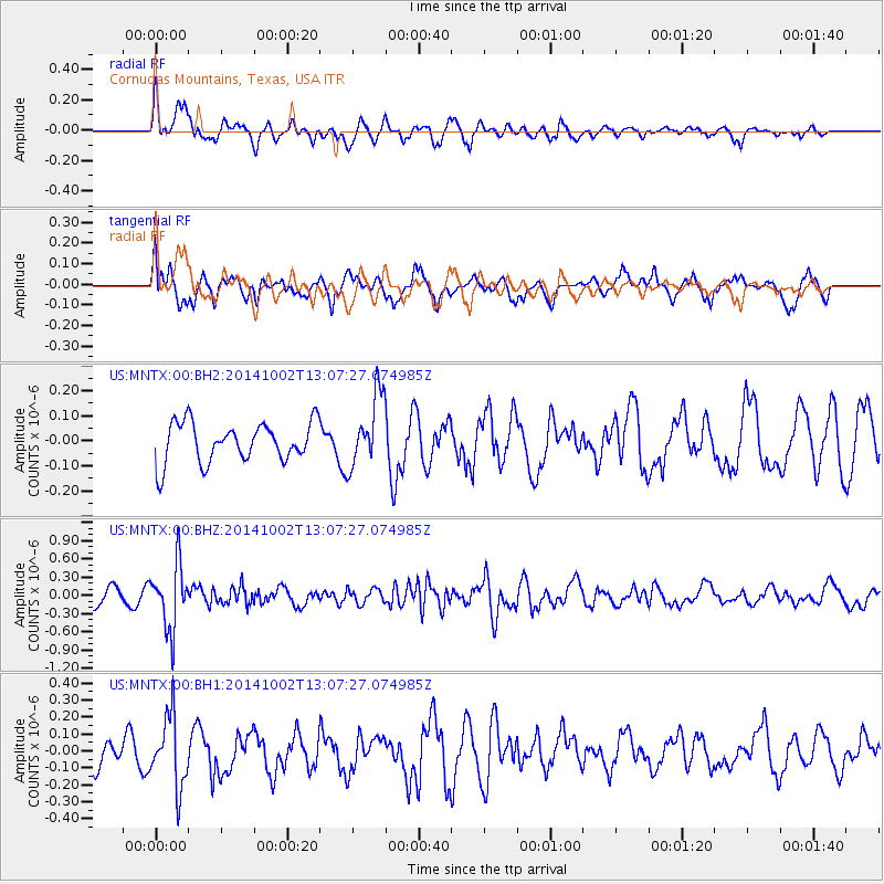
MNTX Cornudas Mountains, Texas, USA - Earthquake Result Viewer
*The percent match for this event was below the threshold and hence no stack was calculated.
| Earthquake location: |
Kamchatka Peninsula, Russia |
| Earthquake latitude/longitude: |
52.4/158.0 |
| Earthquake time(UTC): |
2014/10/02 (275) 12:57:06 GMT |
| Earthquake Depth: |
150 km |
| Earthquake Magnitude: |
5.7 MB |
| Earthquake Catalog/Contributor: |
NEIC PDE/NEIC COMCAT |
|
| Network: |
US United States National Seismic Network |
| Station: |
MNTX Cornudas Mountains, Texas, USA |
| Lat/Lon: |
31.70 N/105.38 W |
| Elevation: |
404 m |
|
| Distance: |
69.3 deg |
| Az: |
64.805 deg |
| Baz: |
319.403 deg |
| Ray Param: |
$rayparam |
*The percent match for this event was below the threshold and hence was not used in the summary stack. |
|
| Radial Match: |
71.1694 % |
| Radial Bump: |
400 |
| Transverse Match: |
52.881363 % |
| Transverse Bump: |
400 |
| SOD ConfigId: |
796777 |
| Insert Time: |
2014-10-16 13:53:13.285 +0000 |
| GWidth: |
2.5 |
| Max Bumps: |
400 |
| Tol: |
0.001 |
|
Signal To Noise
| Channel | StoN | STA | LTA |
| US:MNTX:00:BHZ:20141002T13:07:27.074985Z | 4.281706 | 5.257929E-7 | 1.2279988E-7 |
| US:MNTX:00:BH1:20141002T13:07:27.074985Z | 3.0465975 | 2.0756046E-7 | 6.8128614E-8 |
| US:MNTX:00:BH2:20141002T13:07:27.074985Z | 1.8156763 | 1.430832E-7 | 7.8804355E-8 |
| Arrivals |
| Ps | |
| PpPs | |
| PsPs/PpSs | |


