You are here: Home > Network List > UW - Pacific Northwest Regional Seismic Network Stations List
> Station MRBL Marblemount, WA, USA > Earthquake Result Viewer
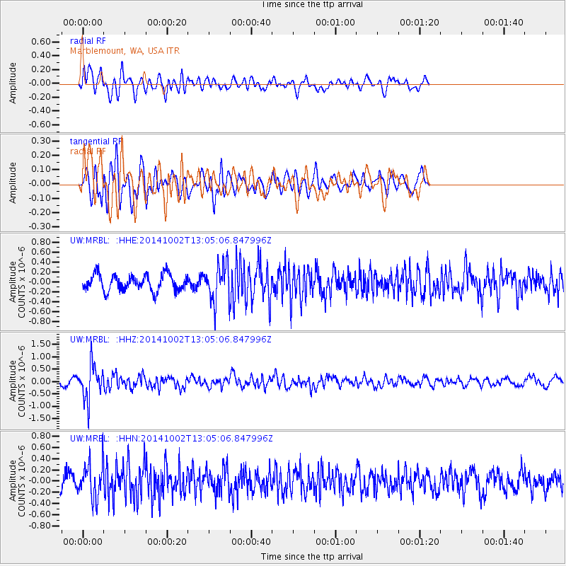
MRBL Marblemount, WA, USA - Earthquake Result Viewer
*The percent match for this event was below the threshold and hence no stack was calculated.
| Earthquake location: |
Kamchatka Peninsula, Russia |
| Earthquake latitude/longitude: |
52.4/158.0 |
| Earthquake time(UTC): |
2014/10/02 (275) 12:57:06 GMT |
| Earthquake Depth: |
150 km |
| Earthquake Magnitude: |
5.7 MB |
| Earthquake Catalog/Contributor: |
NEIC PDE/NEIC COMCAT |
|
| Network: |
UW Pacific Northwest Regional Seismic Network |
| Station: |
MRBL Marblemount, WA, USA |
| Lat/Lon: |
48.52 N/121.48 W |
| Elevation: |
75 m |
|
| Distance: |
48.9 deg |
| Az: |
60.473 deg |
| Baz: |
306.657 deg |
| Ray Param: |
$rayparam |
*The percent match for this event was below the threshold and hence was not used in the summary stack. |
|
| Radial Match: |
58.680874 % |
| Radial Bump: |
400 |
| Transverse Match: |
67.74182 % |
| Transverse Bump: |
400 |
| SOD ConfigId: |
796777 |
| Insert Time: |
2014-10-16 13:55:46.552 +0000 |
| GWidth: |
2.5 |
| Max Bumps: |
400 |
| Tol: |
0.001 |
|
Signal To Noise
| Channel | StoN | STA | LTA |
| UW:MRBL: :HHZ:20141002T13:05:06.847996Z | 7.074428 | 7.070593E-7 | 9.994579E-8 |
| UW:MRBL: :HHN:20141002T13:05:06.847996Z | 2.157891 | 3.0696526E-7 | 1.4225243E-7 |
| UW:MRBL: :HHE:20141002T13:05:06.847996Z | 2.2510977 | 3.642571E-7 | 1.618131E-7 |
| Arrivals |
| Ps | |
| PpPs | |
| PsPs/PpSs | |


