You are here: Home > Network List > UW - Pacific Northwest Regional Seismic Network Stations List
> Station UMAT Pilot Rock, OR, USA > Earthquake Result Viewer
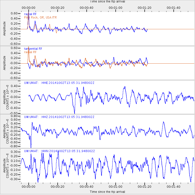
UMAT Pilot Rock, OR, USA - Earthquake Result Viewer
*The percent match for this event was below the threshold and hence no stack was calculated.
| Earthquake location: |
Kamchatka Peninsula, Russia |
| Earthquake latitude/longitude: |
52.4/158.0 |
| Earthquake time(UTC): |
2014/10/02 (275) 12:57:06 GMT |
| Earthquake Depth: |
150 km |
| Earthquake Magnitude: |
5.7 MB |
| Earthquake Catalog/Contributor: |
NEIC PDE/NEIC COMCAT |
|
| Network: |
UW Pacific Northwest Regional Seismic Network |
| Station: |
UMAT Pilot Rock, OR, USA |
| Lat/Lon: |
45.29 N/118.96 W |
| Elevation: |
1318 m |
|
| Distance: |
52.3 deg |
| Az: |
62.372 deg |
| Baz: |
309.702 deg |
| Ray Param: |
$rayparam |
*The percent match for this event was below the threshold and hence was not used in the summary stack. |
|
| Radial Match: |
71.1113 % |
| Radial Bump: |
374 |
| Transverse Match: |
50.070152 % |
| Transverse Bump: |
400 |
| SOD ConfigId: |
796777 |
| Insert Time: |
2014-10-16 13:56:08.697 +0000 |
| GWidth: |
2.5 |
| Max Bumps: |
400 |
| Tol: |
0.001 |
|
Signal To Noise
| Channel | StoN | STA | LTA |
| UW:UMAT: :HHZ:20141002T13:05:31.948002Z | 4.108787 | 3.1473533E-7 | 7.660054E-8 |
| UW:UMAT: :HHN:20141002T13:05:31.948002Z | 1.3998729 | 1.0886885E-7 | 7.777053E-8 |
| UW:UMAT: :HHE:20141002T13:05:31.948002Z | 3.5617964 | 2.6803326E-7 | 7.5252274E-8 |
| Arrivals |
| Ps | |
| PpPs | |
| PsPs/PpSs | |


