You are here: Home > Network List > IU - Global Seismograph Network (GSN - IRIS/USGS) Stations List
> Station WVT Waverly, Tennessee, USA > Earthquake Result Viewer
WVT Waverly, Tennessee, USA - Earthquake Result Viewer
| Earthquake location: |
Northwest Of Kuril Islands |
| Earthquake latitude/longitude: |
47.8/146.2 |
| Earthquake time(UTC): |
2002/11/17 (321) 04:53:53 GMT |
| Earthquake Depth: |
459 km |
| Earthquake Magnitude: |
7.3 MW, 7.3 MW |
| Earthquake Catalog/Contributor: |
WHDF/NEIC |
|
| Network: |
IU Global Seismograph Network (GSN - IRIS/USGS) |
| Station: |
WVT Waverly, Tennessee, USA |
| Lat/Lon: |
36.13 N/87.83 W |
| Elevation: |
157 m |
|
| Distance: |
83.5 deg |
| Az: |
41.264 deg |
| Baz: |
326.702 deg |
| Ray Param: |
0.044871826 |
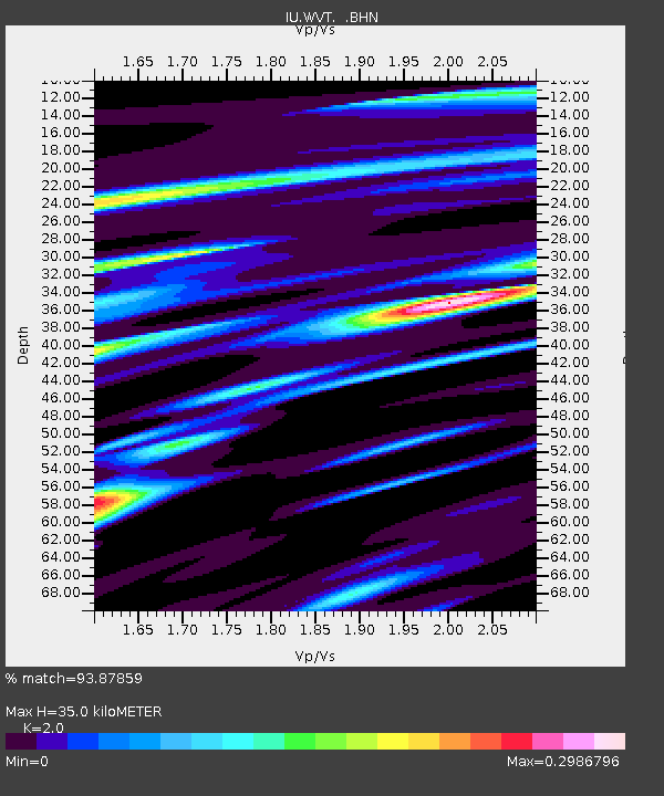
| Estimated Moho Depth: |
35.0 km |
| Estimated Crust Vp/Vs: |
2.00 |
| Assumed Crust Vp: |
6.444 km/s |
| Estimated Crust Vs: |
3.222 km/s |
| Estimated Crust Poisson's Ratio: |
0.33 |
|
| Radial Match: |
93.87859 % |
| Radial Bump: |
272 |
| Transverse Match: |
81.23478 % |
| Transverse Bump: |
400 |
| SOD ConfigId: |
4714 |
| Insert Time: |
2010-03-02 02:01:05.246 +0000 |
| GWidth: |
2.5 |
| Max Bumps: |
400 |
| Tol: |
0.001 |
|

Signal To Noise
| Channel | StoN | STA | LTA |
| IU:WVT: :BHN:20021117T05:05:00.82302Z | 31.488829 | 6.1439705E-6 | 1.9511589E-7 |
| IU:WVT: :BHE:20021117T05:05:00.82302Z | 16.557316 | 3.7457428E-6 | 2.2622886E-7 |
| IU:WVT: :BHZ:20021117T05:05:00.82302Z | 83.350174 | 2.1929876E-5 | 2.6310533E-7 |
| Arrivals |
| Ps | 5.5 SECOND |
| PpPs | 16 SECOND |
| PsPs/PpSs | 21 SECOND |


