You are here: Home > Network List > IU - Global Seismograph Network (GSN - IRIS/USGS) Stations List
> Station KBL Kabul, Afghanistan > Earthquake Result Viewer
KBL Kabul, Afghanistan - Earthquake Result Viewer
| Earthquake location: |
Mariana Islands Region |
| Earthquake latitude/longitude: |
15.5/147.3 |
| Earthquake time(UTC): |
2014/10/06 (279) 14:04:05 GMT |
| Earthquake Depth: |
6.9 km |
| Earthquake Magnitude: |
5.6 MB |
| Earthquake Catalog/Contributor: |
NEIC PDE/NEIC ALERT |
|
| Network: |
IU Global Seismograph Network (GSN - IRIS/USGS) |
| Station: |
KBL Kabul, Afghanistan |
| Lat/Lon: |
34.54 N/69.04 E |
| Elevation: |
1920 m |
|
| Distance: |
71.8 deg |
| Az: |
301.726 deg |
| Baz: |
83.49 deg |
| Ray Param: |
0.0540738 |
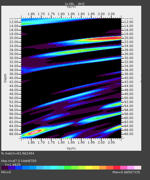
| Estimated Moho Depth: |
67.0 km |
| Estimated Crust Vp/Vs: |
1.66 |
| Assumed Crust Vp: |
6.641 km/s |
| Estimated Crust Vs: |
3.994 km/s |
| Estimated Crust Poisson's Ratio: |
0.22 |
|
| Radial Match: |
93.962494 % |
| Radial Bump: |
400 |
| Transverse Match: |
78.67636 % |
| Transverse Bump: |
400 |
| SOD ConfigId: |
796777 |
| Insert Time: |
2014-10-20 14:26:20.127 +0000 |
| GWidth: |
2.5 |
| Max Bumps: |
400 |
| Tol: |
0.001 |
|
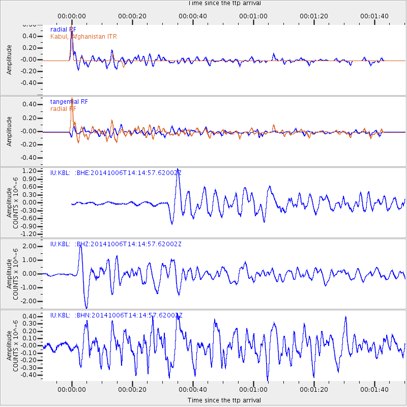
Signal To Noise
| Channel | StoN | STA | LTA |
| IU:KBL: :BHZ:20141006T14:14:57.62002Z | 16.19764 | 1.1691633E-6 | 7.218109E-8 |
| IU:KBL: :BHN:20141006T14:14:57.62002Z | 3.9177446 | 1.4529128E-7 | 3.708544E-8 |
| IU:KBL: :BHE:20141006T14:14:57.62002Z | 11.503791 | 4.2215697E-7 | 3.66972E-8 |
| Arrivals |
| Ps | 7.0 SECOND |
| PpPs | 26 SECOND |
| PsPs/PpSs | 33 SECOND |


