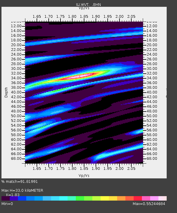
WVT Waverly, Tennessee, USA - Earthquake Result Viewer

Earthquake location: Rat Islands, Aleutian Islands
Earthquake latitude/longitude: 51.3/178.0
Earthquake time(UTC): 2003/03/17 (076) 16:36:17 GMT
Earthquake Depth: 33 km
Earthquake Magnitude: 5.9 MB, 6.7 MS, 7.0 MW, 7.0 MW
Earthquake Catalog/Contributor: WHDF/NEIC
Network: IU Global Seismograph Network (GSN - IRIS/USGS)
Station: WVT Waverly, Tennessee, USA
Lat/Lon: 36.13 N/87.83 W
Elevation: 157 m
Distance: 65.2 deg
Az: 62.808 deg
Baz: 316.355 deg
Ray Param: 0.058380306
Estimated Moho Depth: 33.0 km
Estimated Crust Vp/Vs: 1.83
Assumed Crust Vp: 6.444 km/s
Estimated Crust Vs: 3.521 km/s
Estimated Crust Poisson's Ratio: 0.29
Radial Match: 91.81991 %
Radial Bump: 296
Transverse Match: 69.94221 %
Transverse Bump: 400
SOD ConfigId: 4714
Insert Time: 2010-03-02 02:01:17.166 +0000
GWidth: 2.5
Max Bumps: 400
Tol: 0.001

Signal To Noise

ChannelStoNSTALTA
IU:WVT: :BHN:20030317T16:46:24.435Z3.23924763.9281477E-71.2126729E-7
IU:WVT: :BHE:20030317T16:46:24.435Z2.65917234.5888865E-71.7256822E-7
IU:WVT: :BHZ:20030317T16:46:24.435Z7.491391.121206E-61.4966594E-7
Arrivals
Ps4.4 SECOND
PpPs14 SECOND
PsPs/PpSs18 SECOND