You are here: Home > Network List > TJ - Tajikistan National Seismic Network Stations List
> Station SHAA Shaartuz, Tajikistan > Earthquake Result Viewer
SHAA Shaartuz, Tajikistan - Earthquake Result Viewer
| Earthquake location: |
Mariana Islands Region |
| Earthquake latitude/longitude: |
15.5/147.3 |
| Earthquake time(UTC): |
2014/10/06 (279) 14:04:05 GMT |
| Earthquake Depth: |
6.9 km |
| Earthquake Magnitude: |
5.6 MB |
| Earthquake Catalog/Contributor: |
NEIC PDE/NEIC ALERT |
|
| Network: |
TJ Tajikistan National Seismic Network |
| Station: |
SHAA Shaartuz, Tajikistan |
| Lat/Lon: |
37.56 N/68.12 E |
| Elevation: |
868 m |
|
| Distance: |
72.2 deg |
| Az: |
304.963 deg |
| Baz: |
83.949 deg |
| Ray Param: |
0.053798515 |
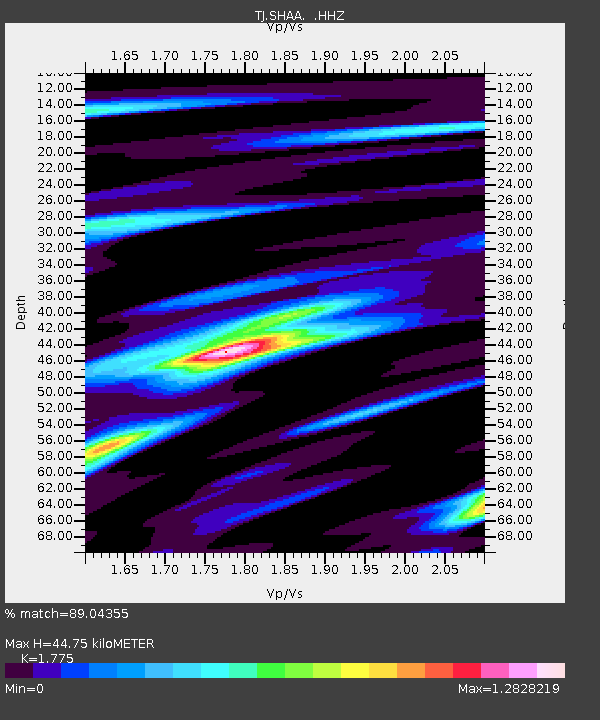
| Estimated Moho Depth: |
44.75 km |
| Estimated Crust Vp/Vs: |
1.77 |
| Assumed Crust Vp: |
6.213 km/s |
| Estimated Crust Vs: |
3.501 km/s |
| Estimated Crust Poisson's Ratio: |
0.27 |
|
| Radial Match: |
89.04355 % |
| Radial Bump: |
371 |
| Transverse Match: |
83.0611 % |
| Transverse Bump: |
340 |
| SOD ConfigId: |
796777 |
| Insert Time: |
2014-10-20 14:34:30.433 +0000 |
| GWidth: |
2.5 |
| Max Bumps: |
400 |
| Tol: |
0.001 |
|

Signal To Noise
| Channel | StoN | STA | LTA |
| TJ:SHAA: :HHZ:20141006T14:15:00.07998Z | 16.469433 | 3.8406574E-6 | 2.3319915E-7 |
| TJ:SHAA: :HHN:20141006T14:15:00.07998Z | 2.2466393 | 3.816074E-7 | 1.69857E-7 |
| TJ:SHAA: :HHE:20141006T14:15:00.07998Z | 4.031822 | 9.856383E-7 | 2.4446473E-7 |
| Arrivals |
| Ps | 5.8 SECOND |
| PpPs | 19 SECOND |
| PsPs/PpSs | 25 SECOND |


