You are here: Home > Network List > US - United States National Seismic Network Stations List
> Station MSO Missoula, Montana, USA > Earthquake Result Viewer
MSO Missoula, Montana, USA - Earthquake Result Viewer
*The percent match for this event was below the threshold and hence no stack was calculated.
| Earthquake location: |
Mariana Islands Region |
| Earthquake latitude/longitude: |
15.5/147.3 |
| Earthquake time(UTC): |
2014/10/06 (279) 14:04:05 GMT |
| Earthquake Depth: |
6.9 km |
| Earthquake Magnitude: |
5.6 MB |
| Earthquake Catalog/Contributor: |
NEIC PDE/NEIC ALERT |
|
| Network: |
US United States National Seismic Network |
| Station: |
MSO Missoula, Montana, USA |
| Lat/Lon: |
46.83 N/113.94 W |
| Elevation: |
1264 m |
|
| Distance: |
84.7 deg |
| Az: |
42.955 deg |
| Baz: |
286.869 deg |
| Ray Param: |
$rayparam |
*The percent match for this event was below the threshold and hence was not used in the summary stack. |
|
| Radial Match: |
50.20696 % |
| Radial Bump: |
356 |
| Transverse Match: |
52.59273 % |
| Transverse Bump: |
400 |
| SOD ConfigId: |
796777 |
| Insert Time: |
2014-10-20 14:35:20.088 +0000 |
| GWidth: |
2.5 |
| Max Bumps: |
400 |
| Tol: |
0.001 |
|
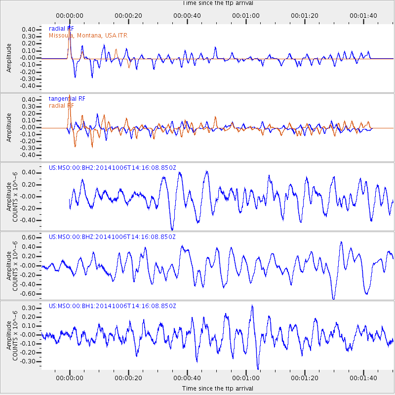
Signal To Noise
| Channel | StoN | STA | LTA |
| US:MSO:00:BHZ:20141006T14:16:08.850Z | 1.0055081 | 1.10695055E-7 | 1.1008868E-7 |
| US:MSO:00:BH1:20141006T14:16:08.850Z | 0.62835157 | 5.6115912E-8 | 8.930655E-8 |
| US:MSO:00:BH2:20141006T14:16:08.850Z | 2.631654 | 2.5285587E-7 | 9.6082495E-8 |
| Arrivals |
| Ps | |
| PpPs | |
| PsPs/PpSs | |


