You are here: Home > Network List > IU - Global Seismograph Network (GSN - IRIS/USGS) Stations List
> Station WVT Waverly, Tennessee, USA > Earthquake Result Viewer
WVT Waverly, Tennessee, USA - Earthquake Result Viewer
| Earthquake location: |
Kamchatka Peninsula, Russia |
| Earthquake latitude/longitude: |
55.7/160.0 |
| Earthquake time(UTC): |
2004/06/10 (162) 15:19:57 GMT |
| Earthquake Depth: |
189 km |
| Earthquake Magnitude: |
6.1 MB, 6.9 MW, 6.9 MW |
| Earthquake Catalog/Contributor: |
WHDF/NEIC |
|
| Network: |
IU Global Seismograph Network (GSN - IRIS/USGS) |
| Station: |
WVT Waverly, Tennessee, USA |
| Lat/Lon: |
36.13 N/87.83 W |
| Elevation: |
157 m |
|
| Distance: |
71.9 deg |
| Az: |
52.073 deg |
| Baz: |
326.507 deg |
| Ray Param: |
0.053512808 |
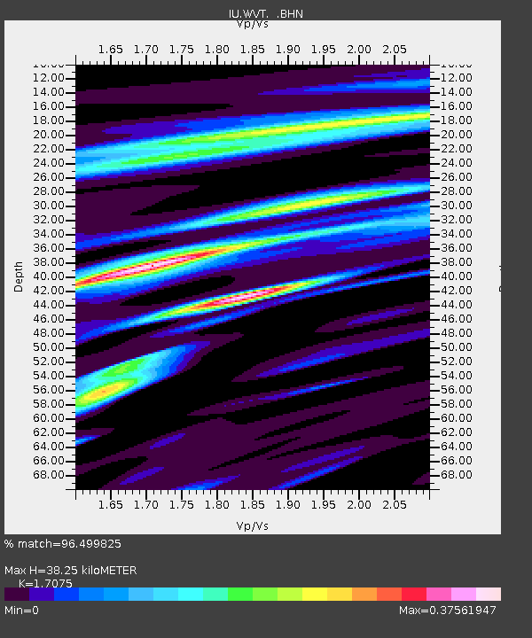
| Estimated Moho Depth: |
38.25 km |
| Estimated Crust Vp/Vs: |
1.71 |
| Assumed Crust Vp: |
6.444 km/s |
| Estimated Crust Vs: |
3.774 km/s |
| Estimated Crust Poisson's Ratio: |
0.24 |
|
| Radial Match: |
96.499825 % |
| Radial Bump: |
400 |
| Transverse Match: |
81.18842 % |
| Transverse Bump: |
400 |
| SOD ConfigId: |
2459 |
| Insert Time: |
2010-03-02 02:01:30.267 +0000 |
| GWidth: |
2.5 |
| Max Bumps: |
400 |
| Tol: |
0.001 |
|

Signal To Noise
| Channel | StoN | STA | LTA |
| IU:WVT: :BHN:20040610T15:30:29.27301Z | 8.02802 | 9.648153E-7 | 1.2018099E-7 |
| IU:WVT: :BHE:20040610T15:30:29.27301Z | 6.72818 | 7.658771E-7 | 1.1383125E-7 |
| IU:WVT: :BHZ:20040610T15:30:29.27301Z | 45.791943 | 3.1611235E-6 | 6.903231E-8 |
| Arrivals |
| Ps | 4.4 SECOND |
| PpPs | 15 SECOND |
| PsPs/PpSs | 20 SECOND |


