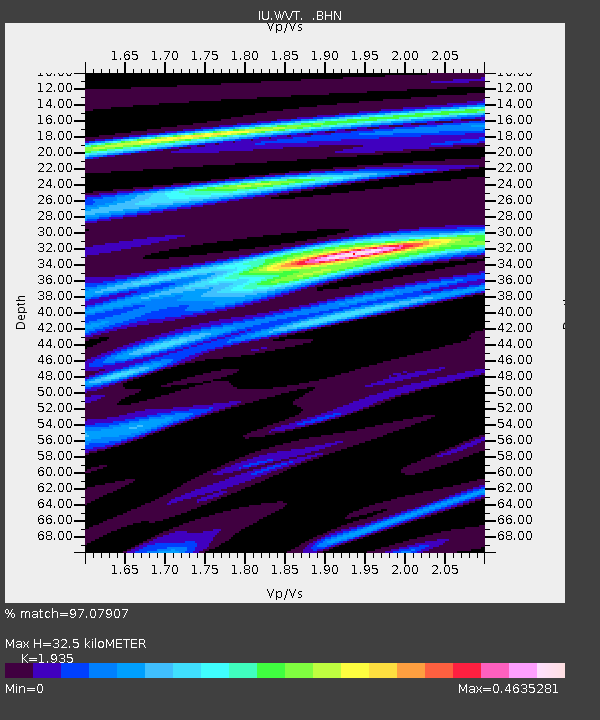
WVT Waverly, Tennessee, USA - Earthquake Result Viewer

Earthquake location: Andreanof Islands, Aleutian Is.
Earthquake latitude/longitude: 51.9/-177.5
Earthquake time(UTC): 2008/05/02 (123) 01:33:37 GMT
Earthquake Depth: 14 km
Earthquake Magnitude: 6.3 MB, 6.8 MS, 6.6 MW, 6.6 MW
Earthquake Catalog/Contributor: WHDF/NEIC
Network: IU Global Seismograph Network (GSN - IRIS/USGS)
Station: WVT Waverly, Tennessee, USA
Lat/Lon: 36.13 N/87.83 W
Elevation: 157 m
Distance: 62.4 deg
Az: 65.986 deg
Baz: 315.6 deg
Ray Param: 0.060237937
Estimated Moho Depth: 32.5 km
Estimated Crust Vp/Vs: 1.93
Assumed Crust Vp: 6.444 km/s
Estimated Crust Vs: 3.33 km/s
Estimated Crust Poisson's Ratio: 0.32
Radial Match: 97.07907 %
Radial Bump: 287
Transverse Match: 77.210556 %
Transverse Bump: 400
SOD ConfigId: 2504
Insert Time: 2010-03-02 02:01:41.486 +0000
GWidth: 2.5
Max Bumps: 400
Tol: 0.001

Signal To Noise

ChannelStoNSTALTA
IU:WVT: :BHN:20080502T01:43:28.409006Z13.7490691.3471483E-69.798106E-8
IU:WVT: :BHE:20080502T01:43:28.409006Z5.18529464.0843105E-77.876718E-8
IU:WVT: :BHZ:20080502T01:43:28.409006Z4.66485174.598961E-79.8587506E-8
Arrivals
Ps4.9 SECOND
PpPs14 SECOND
PsPs/PpSs19 SECOND