You are here: Home > Network List > II - Global Seismograph Network (GSN - IRIS/IDA) Stations List
> Station WRAB Tennant Creek, NT, Australia > Earthquake Result Viewer
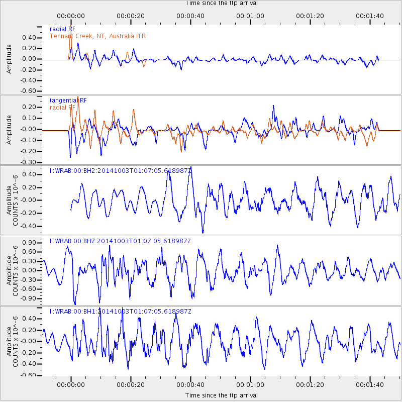
WRAB Tennant Creek, NT, Australia - Earthquake Result Viewer
*The percent match for this event was below the threshold and hence no stack was calculated.
| Earthquake location: |
Near East Coast Of Honshu, Japan |
| Earthquake latitude/longitude: |
40.2/142.8 |
| Earthquake time(UTC): |
2014/10/03 (276) 00:57:30 GMT |
| Earthquake Depth: |
30 km |
| Earthquake Magnitude: |
5.5 MWW, 5.5 MWB, 5.6 MWC |
| Earthquake Catalog/Contributor: |
NEIC PDE/NEIC COMCAT |
|
| Network: |
II Global Seismograph Network (GSN - IRIS/IDA) |
| Station: |
WRAB Tennant Creek, NT, Australia |
| Lat/Lon: |
19.93 S/134.36 E |
| Elevation: |
366 m |
|
| Distance: |
60.3 deg |
| Az: |
189.114 deg |
| Baz: |
7.414 deg |
| Ray Param: |
$rayparam |
*The percent match for this event was below the threshold and hence was not used in the summary stack. |
|
| Radial Match: |
75.73777 % |
| Radial Bump: |
400 |
| Transverse Match: |
57.70262 % |
| Transverse Bump: |
400 |
| SOD ConfigId: |
796777 |
| Insert Time: |
2014-10-21 01:33:27.234 +0000 |
| GWidth: |
2.5 |
| Max Bumps: |
400 |
| Tol: |
0.001 |
|
Signal To Noise
| Channel | StoN | STA | LTA |
| II:WRAB:00:BHZ:20141003T01:07:05.618987Z | 2.8806698 | 5.401997E-7 | 1.8752574E-7 |
| II:WRAB:00:BH1:20141003T01:07:05.618987Z | 1.4628834 | 2.1382893E-7 | 1.461695E-7 |
| II:WRAB:00:BH2:20141003T01:07:05.618987Z | 1.7460607 | 2.3718735E-7 | 1.358414E-7 |
| Arrivals |
| Ps | |
| PpPs | |
| PsPs/PpSs | |


