You are here: Home > Network List > AU - Australian Seismological Centre Stations List
> Station XMI Christmas Island Airport > Earthquake Result Viewer
XMI Christmas Island Airport - Earthquake Result Viewer
| Earthquake location: |
New Britain Region, P.N.G. |
| Earthquake latitude/longitude: |
-5.2/151.8 |
| Earthquake time(UTC): |
2015/05/01 (121) 08:06:05 GMT |
| Earthquake Depth: |
54 km |
| Earthquake Magnitude: |
7.1 MO |
| Earthquake Catalog/Contributor: |
NEIC PDE/NEIC ALERT |
|
| Network: |
AU Australian Seismological Centre |
| Station: |
XMI Christmas Island Airport |
| Lat/Lon: |
10.45 S/105.69 E |
| Elevation: |
252 m |
|
| Distance: |
45.9 deg |
| Az: |
260.558 deg |
| Baz: |
87.157 deg |
| Ray Param: |
0.070824794 |
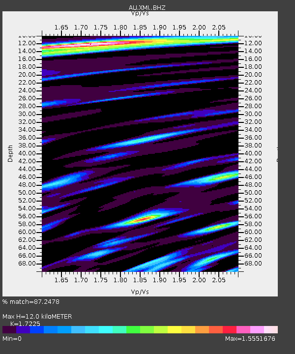
| Estimated Moho Depth: |
12.0 km |
| Estimated Crust Vp/Vs: |
1.72 |
| Assumed Crust Vp: |
4.157 km/s |
| Estimated Crust Vs: |
2.413 km/s |
| Estimated Crust Poisson's Ratio: |
0.25 |
|
| Radial Match: |
87.2478 % |
| Radial Bump: |
400 |
| Transverse Match: |
74.88449 % |
| Transverse Bump: |
400 |
| SOD ConfigId: |
7422571 |
| Insert Time: |
2019-04-18 14:56:54.314 +0000 |
| GWidth: |
2.5 |
| Max Bumps: |
400 |
| Tol: |
0.001 |
|

Signal To Noise
| Channel | StoN | STA | LTA |
| AU:XMI: :BHZ:20150501T08:13:51.318994Z | 3.4566634 | 4.9574196E-6 | 1.4341632E-6 |
| AU:XMI: :BHN:20150501T08:13:51.318994Z | 0.59785277 | 1.4318325E-6 | 2.3949585E-6 |
| AU:XMI: :BHE:20150501T08:13:51.318994Z | 4.6354012 | 4.371134E-6 | 9.4298935E-7 |
| Arrivals |
| Ps | 2.1 SECOND |
| PpPs | 7.7 SECOND |
| PsPs/PpSs | 9.8 SECOND |


