You are here: Home > Network List > IU - Global Seismograph Network (GSN - IRIS/USGS) Stations List
> Station WVT Waverly, Tennessee, USA > Earthquake Result Viewer
WVT Waverly, Tennessee, USA - Earthquake Result Viewer
| Earthquake location: |
Dodecanese Islands, Greece |
| Earthquake latitude/longitude: |
35.8/27.9 |
| Earthquake time(UTC): |
2008/07/15 (197) 03:26:34 GMT |
| Earthquake Depth: |
52 km |
| Earthquake Magnitude: |
6.5 MB, 6.4 MW, 6.4 MW |
| Earthquake Catalog/Contributor: |
WHDF/NEIC |
|
| Network: |
IU Global Seismograph Network (GSN - IRIS/USGS) |
| Station: |
WVT Waverly, Tennessee, USA |
| Lat/Lon: |
36.13 N/87.83 W |
| Elevation: |
157 m |
|
| Distance: |
86.8 deg |
| Az: |
313.054 deg |
| Baz: |
47.201 deg |
| Ray Param: |
0.04373019 |
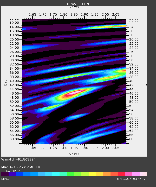
| Estimated Moho Depth: |
45.25 km |
| Estimated Crust Vp/Vs: |
1.85 |
| Assumed Crust Vp: |
6.444 km/s |
| Estimated Crust Vs: |
3.478 km/s |
| Estimated Crust Poisson's Ratio: |
0.29 |
|
| Radial Match: |
91.803894 % |
| Radial Bump: |
400 |
| Transverse Match: |
78.21552 % |
| Transverse Bump: |
400 |
| SOD ConfigId: |
2504 |
| Insert Time: |
2010-03-02 02:01:53.702 +0000 |
| GWidth: |
2.5 |
| Max Bumps: |
400 |
| Tol: |
0.001 |
|

Signal To Noise
| Channel | StoN | STA | LTA |
| IU:WVT: :BHN:20080715T03:38:42.009998Z | 43.821575 | 1.6484651E-6 | 3.7617657E-8 |
| IU:WVT: :BHE:20080715T03:38:42.009998Z | 8.330739 | 4.374499E-7 | 5.2510334E-8 |
| IU:WVT: :BHZ:20080715T03:38:42.009998Z | 13.121534 | 5.48339E-7 | 4.1789246E-8 |
| Arrivals |
| Ps | 6.1 SECOND |
| PpPs | 20 SECOND |
| PsPs/PpSs | 26 SECOND |


