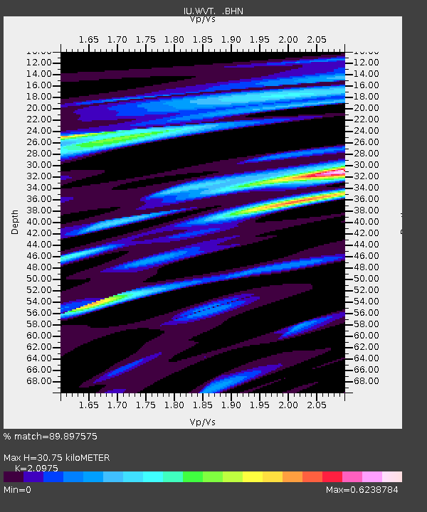
WVT Waverly, Tennessee, USA - Earthquake Result Viewer

Earthquake location: Rat Islands, Aleutian Islands
Earthquake latitude/longitude: 51.3/179.0
Earthquake time(UTC): 2008/07/25 (207) 00:29:22 GMT
Earthquake Depth: 21 km
Earthquake Magnitude: 5.7 MB, 5.5 MS, 5.9 MW, 5.9 MW
Earthquake Catalog/Contributor: WHDF/NEIC
Network: IU Global Seismograph Network (GSN - IRIS/USGS)
Station: WVT Waverly, Tennessee, USA
Lat/Lon: 36.13 N/87.83 W
Elevation: 157 m
Distance: 64.6 deg
Az: 63.458 deg
Baz: 316.047 deg
Ray Param: 0.058778062
Estimated Moho Depth: 30.75 km
Estimated Crust Vp/Vs: 2.10
Assumed Crust Vp: 6.444 km/s
Estimated Crust Vs: 3.072 km/s
Estimated Crust Poisson's Ratio: 0.35
Radial Match: 89.897575 %
Radial Bump: 392
Transverse Match: 68.86861 %
Transverse Bump: 400
SOD ConfigId: 2504
Insert Time: 2010-03-02 02:01:58.716 +0000
GWidth: 2.5
Max Bumps: 400
Tol: 0.001

Signal To Noise

ChannelStoNSTALTA
IU:WVT: :BHN:20080725T00:39:27.810027Z13.75062756.118536E-74.4496407E-8
IU:WVT: :BHE:20080725T00:39:27.810027Z3.57363821.8307591E-75.122956E-8
IU:WVT: :BHZ:20080725T00:39:27.810027Z6.77121352.3440683E-73.4618143E-8
Arrivals
Ps5.4 SECOND
PpPs14 SECOND
PsPs/PpSs20 SECOND