You are here: Home > Network List > TA - USArray Transportable Network (new EarthScope stations) Stations List
> Station O03E Paynes Creek, CA, USA > Earthquake Result Viewer
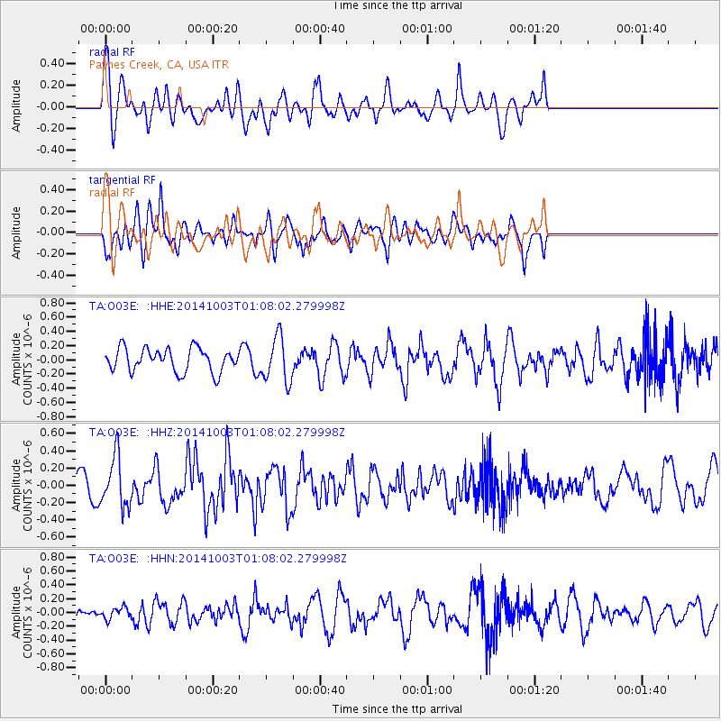
O03E Paynes Creek, CA, USA - Earthquake Result Viewer
*The percent match for this event was below the threshold and hence no stack was calculated.
| Earthquake location: |
Near East Coast Of Honshu, Japan |
| Earthquake latitude/longitude: |
40.2/142.8 |
| Earthquake time(UTC): |
2014/10/03 (276) 00:57:30 GMT |
| Earthquake Depth: |
30 km |
| Earthquake Magnitude: |
5.5 MWW, 5.5 MWB, 5.6 MWC |
| Earthquake Catalog/Contributor: |
NEIC PDE/NEIC COMCAT |
|
| Network: |
TA USArray Transportable Network (new EarthScope stations) |
| Station: |
O03E Paynes Creek, CA, USA |
| Lat/Lon: |
40.29 N/121.80 W |
| Elevation: |
967 m |
|
| Distance: |
69.0 deg |
| Az: |
54.647 deg |
| Baz: |
305.191 deg |
| Ray Param: |
$rayparam |
*The percent match for this event was below the threshold and hence was not used in the summary stack. |
|
| Radial Match: |
63.06461 % |
| Radial Bump: |
400 |
| Transverse Match: |
65.98651 % |
| Transverse Bump: |
400 |
| SOD ConfigId: |
796777 |
| Insert Time: |
2014-10-21 01:45:50.646 +0000 |
| GWidth: |
2.5 |
| Max Bumps: |
400 |
| Tol: |
0.001 |
|
Signal To Noise
| Channel | StoN | STA | LTA |
| TA:O03E: :HHZ:20141003T01:08:02.279998Z | 3.3520007 | 2.9030082E-7 | 8.660523E-8 |
| TA:O03E: :HHN:20141003T01:08:02.279998Z | 0.36835477 | 8.289254E-8 | 2.2503453E-7 |
| TA:O03E: :HHE:20141003T01:08:02.279998Z | 1.9524345 | 3.203278E-7 | 1.6406584E-7 |
| Arrivals |
| Ps | |
| PpPs | |
| PsPs/PpSs | |


