You are here: Home > Network List > TA - USArray Transportable Network (new EarthScope stations) Stations List
> Station V57A Coltrane Farms, NC, USA > Earthquake Result Viewer
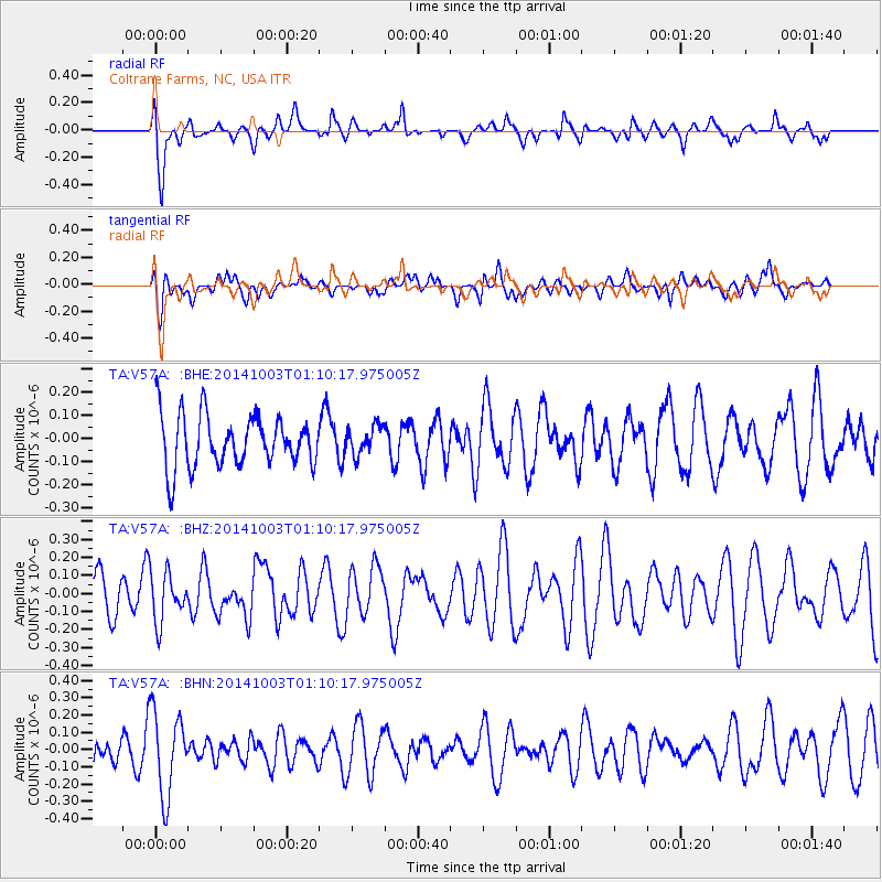
V57A Coltrane Farms, NC, USA - Earthquake Result Viewer
*The percent match for this event was below the threshold and hence no stack was calculated.
| Earthquake location: |
Near East Coast Of Honshu, Japan |
| Earthquake latitude/longitude: |
40.2/142.8 |
| Earthquake time(UTC): |
2014/10/03 (276) 00:57:30 GMT |
| Earthquake Depth: |
30 km |
| Earthquake Magnitude: |
5.5 MWW, 5.5 MWB, 5.6 MWC |
| Earthquake Catalog/Contributor: |
NEIC PDE/NEIC COMCAT |
|
| Network: |
TA USArray Transportable Network (new EarthScope stations) |
| Station: |
V57A Coltrane Farms, NC, USA |
| Lat/Lon: |
35.89 N/79.78 W |
| Elevation: |
223 m |
|
| Distance: |
94.8 deg |
| Az: |
33.435 deg |
| Baz: |
328.666 deg |
| Ray Param: |
$rayparam |
*The percent match for this event was below the threshold and hence was not used in the summary stack. |
|
| Radial Match: |
61.42453 % |
| Radial Bump: |
400 |
| Transverse Match: |
50.472866 % |
| Transverse Bump: |
400 |
| SOD ConfigId: |
796777 |
| Insert Time: |
2014-10-21 01:47:04.232 +0000 |
| GWidth: |
2.5 |
| Max Bumps: |
400 |
| Tol: |
0.001 |
|
Signal To Noise
| Channel | StoN | STA | LTA |
| TA:V57A: :BHZ:20141003T01:10:17.975005Z | 0.8228976 | 1.35844E-7 | 1.6508008E-7 |
| TA:V57A: :BHN:20141003T01:10:17.975005Z | 2.487262 | 2.414505E-7 | 9.707481E-8 |
| TA:V57A: :BHE:20141003T01:10:17.975005Z | 0.5359068 | 6.056287E-8 | 1.13010074E-7 |
| Arrivals |
| Ps | |
| PpPs | |
| PsPs/PpSs | |


