You are here: Home > Network List > TA - USArray Transportable Network (new EarthScope stations) Stations List
> Station X43A Marvell, AR, USA > Earthquake Result Viewer
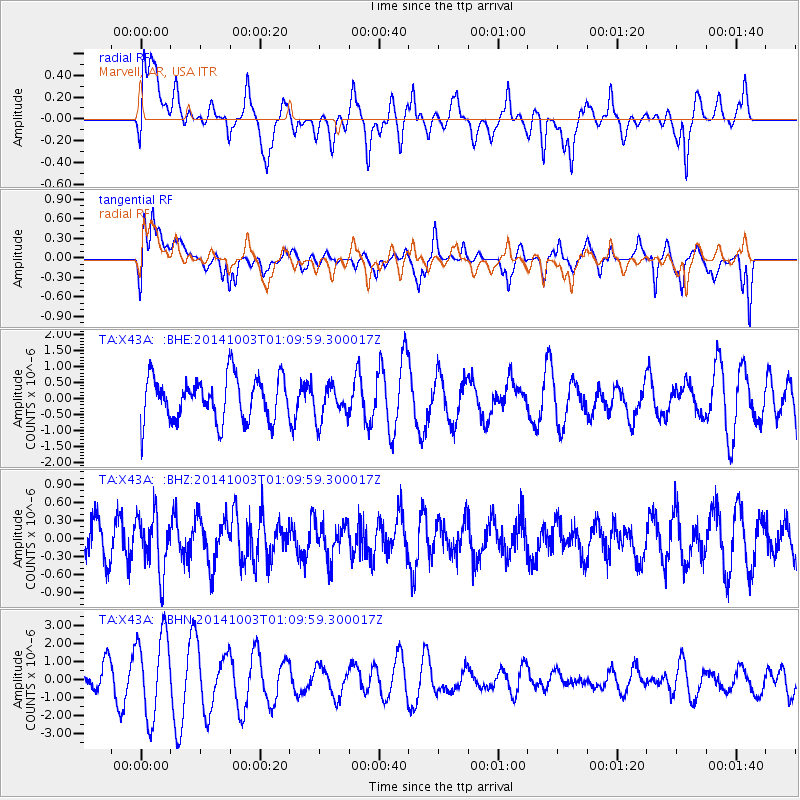
X43A Marvell, AR, USA - Earthquake Result Viewer
*The percent match for this event was below the threshold and hence no stack was calculated.
| Earthquake location: |
Near East Coast Of Honshu, Japan |
| Earthquake latitude/longitude: |
40.2/142.8 |
| Earthquake time(UTC): |
2014/10/03 (276) 00:57:30 GMT |
| Earthquake Depth: |
30 km |
| Earthquake Magnitude: |
5.5 MWW, 5.5 MWB, 5.6 MWC |
| Earthquake Catalog/Contributor: |
NEIC PDE/NEIC COMCAT |
|
| Network: |
TA USArray Transportable Network (new EarthScope stations) |
| Station: |
X43A Marvell, AR, USA |
| Lat/Lon: |
34.52 N/90.88 W |
| Elevation: |
53 m |
|
| Distance: |
90.7 deg |
| Az: |
41.69 deg |
| Baz: |
321.88 deg |
| Ray Param: |
$rayparam |
*The percent match for this event was below the threshold and hence was not used in the summary stack. |
|
| Radial Match: |
24.949413 % |
| Radial Bump: |
330 |
| Transverse Match: |
29.869045 % |
| Transverse Bump: |
332 |
| SOD ConfigId: |
796777 |
| Insert Time: |
2014-10-21 01:47:21.355 +0000 |
| GWidth: |
2.5 |
| Max Bumps: |
400 |
| Tol: |
0.001 |
|
Signal To Noise
| Channel | StoN | STA | LTA |
| TA:X43A: :BHZ:20141003T01:09:59.300017Z | 1.6078026 | 4.6361686E-7 | 2.8835433E-7 |
| TA:X43A: :BHN:20141003T01:09:59.300017Z | 3.3011067 | 2.3296507E-6 | 7.057181E-7 |
| TA:X43A: :BHE:20141003T01:09:59.300017Z | 0.7926134 | 5.4432115E-7 | 6.867424E-7 |
| Arrivals |
| Ps | |
| PpPs | |
| PsPs/PpSs | |


