You are here: Home > Network List > CI - Caltech Regional Seismic Network Stations List
> Station SMM Simmler, CA, USA > Earthquake Result Viewer
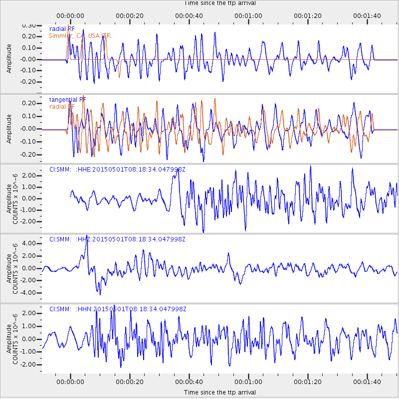
SMM Simmler, CA, USA - Earthquake Result Viewer
*The percent match for this event was below the threshold and hence no stack was calculated.
| Earthquake location: |
New Britain Region, P.N.G. |
| Earthquake latitude/longitude: |
-5.2/151.8 |
| Earthquake time(UTC): |
2015/05/01 (121) 08:06:05 GMT |
| Earthquake Depth: |
54 km |
| Earthquake Magnitude: |
7.1 MO |
| Earthquake Catalog/Contributor: |
NEIC PDE/NEIC ALERT |
|
| Network: |
CI Caltech Regional Seismic Network |
| Station: |
SMM Simmler, CA, USA |
| Lat/Lon: |
35.31 N/120.00 W |
| Elevation: |
599 m |
|
| Distance: |
91.5 deg |
| Az: |
54.858 deg |
| Baz: |
264.744 deg |
| Ray Param: |
$rayparam |
*The percent match for this event was below the threshold and hence was not used in the summary stack. |
|
| Radial Match: |
53.308334 % |
| Radial Bump: |
400 |
| Transverse Match: |
58.56581 % |
| Transverse Bump: |
400 |
| SOD ConfigId: |
7422571 |
| Insert Time: |
2019-04-18 14:58:32.508 +0000 |
| GWidth: |
2.5 |
| Max Bumps: |
400 |
| Tol: |
0.001 |
|
Signal To Noise
| Channel | StoN | STA | LTA |
| CI:SMM: :HHZ:20150501T08:18:34.047998Z | 2.473327 | 1.1588533E-6 | 4.6854024E-7 |
| CI:SMM: :HHN:20150501T08:18:34.047998Z | 1.1572182 | 5.6831846E-7 | 4.911074E-7 |
| CI:SMM: :HHE:20150501T08:18:34.047998Z | 2.8512394 | 1.0693709E-6 | 3.7505478E-7 |
| Arrivals |
| Ps | |
| PpPs | |
| PsPs/PpSs | |


