You are here: Home > Network List > IU - Global Seismograph Network (GSN - IRIS/USGS) Stations List
> Station WVT Waverly, Tennessee, USA > Earthquake Result Viewer
WVT Waverly, Tennessee, USA - Earthquake Result Viewer

| Earthquake location: |
Near Coast Of Venezuela |
| Earthquake latitude/longitude: |
10.6/-63.5 |
| Earthquake time(UTC): |
1997/07/09 (190) 19:24:13 GMT |
| Earthquake Depth: |
20 km |
| Earthquake Magnitude: |
6.2 MB, 6.8 MS, 7.0 UNKNOWN, 6.6 ME |
| Earthquake Catalog/Contributor: |
WHDF/NEIC |
|
| Network: |
IU Global Seismograph Network (GSN - IRIS/USGS) |
| Station: |
WVT Waverly, Tennessee, USA |
| Lat/Lon: |
36.13 N/87.83 W |
| Elevation: |
157 m |
|
| Distance: |
33.7 deg |
| Az: |
322.97 deg |
| Baz: |
132.999 deg |
| Ray Param: |
0.078088395 |
| Estimated Moho Depth: |
60.0 km |
| Estimated Crust Vp/Vs: |
1.60 |
| Assumed Crust Vp: |
6.444 km/s |
| Estimated Crust Vs: |
4.027 km/s |
| Estimated Crust Poisson's Ratio: |
0.18 |
|
| Radial Match: |
93.64746 % |
| Radial Bump: |
385 |
| Transverse Match: |
53.626293 % |
| Transverse Bump: |
400 |
| SOD ConfigId: |
6273 |
| Insert Time: |
2010-03-02 02:02:18.029 +0000 |
| GWidth: |
2.5 |
| Max Bumps: |
400 |
| Tol: |
0.001 |
|
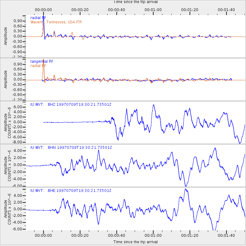
Signal To Noise
| Channel | StoN | STA | LTA |
| IU:WVT: :BHN:19970709T19:30:21.73501Z | 0.5967977 | 3.793248E-7 | 6.356003E-7 |
| IU:WVT: :BHE:19970709T19:30:21.73501Z | 1.336646 | 4.1845644E-7 | 3.1306453E-7 |
| IU:WVT: :BHZ:19970709T19:30:21.73501Z | 4.616595 | 2.9861374E-7 | 6.468269E-8 |
| Arrivals |
| Ps | 6.1 SECOND |
| PpPs | 22 SECOND |
| PsPs/PpSs | 28 SECOND |


