You are here: Home > Network List > IC - New China Digital Seismograph Network Stations List
> Station KMI Kunming, Yunnan Province, China > Earthquake Result Viewer
KMI Kunming, Yunnan Province, China - Earthquake Result Viewer
| Earthquake location: |
New Britain Region, P.N.G. |
| Earthquake latitude/longitude: |
-5.2/151.8 |
| Earthquake time(UTC): |
2015/05/01 (121) 08:06:05 GMT |
| Earthquake Depth: |
54 km |
| Earthquake Magnitude: |
7.1 MO |
| Earthquake Catalog/Contributor: |
NEIC PDE/NEIC ALERT |
|
| Network: |
IC New China Digital Seismograph Network |
| Station: |
KMI Kunming, Yunnan Province, China |
| Lat/Lon: |
25.12 N/102.74 E |
| Elevation: |
1975 m |
|
| Distance: |
56.4 deg |
| Az: |
304.713 deg |
| Baz: |
115.431 deg |
| Ray Param: |
0.06405029 |
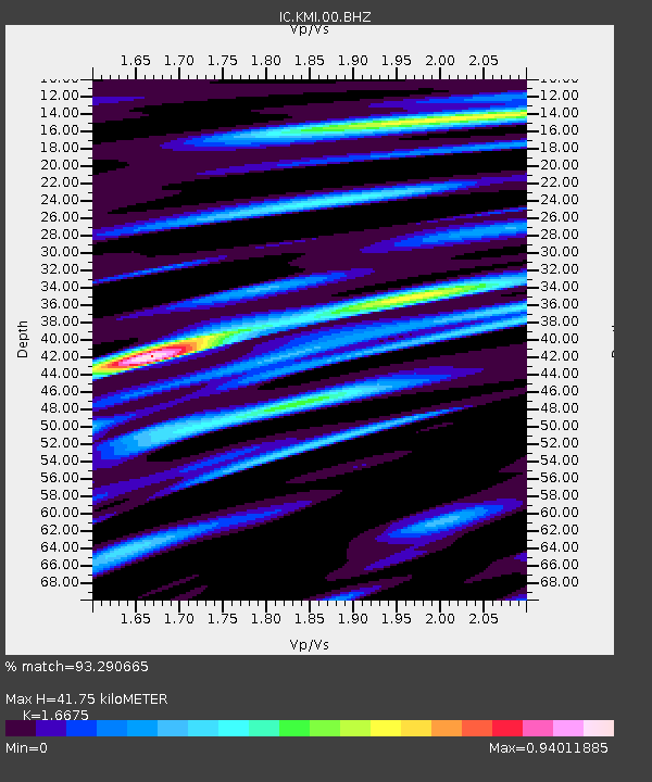
| Estimated Moho Depth: |
41.75 km |
| Estimated Crust Vp/Vs: |
1.67 |
| Assumed Crust Vp: |
6.247 km/s |
| Estimated Crust Vs: |
3.746 km/s |
| Estimated Crust Poisson's Ratio: |
0.22 |
|
| Radial Match: |
93.290665 % |
| Radial Bump: |
400 |
| Transverse Match: |
83.43126 % |
| Transverse Bump: |
400 |
| SOD ConfigId: |
7422571 |
| Insert Time: |
2019-04-18 14:59:11.469 +0000 |
| GWidth: |
2.5 |
| Max Bumps: |
400 |
| Tol: |
0.001 |
|
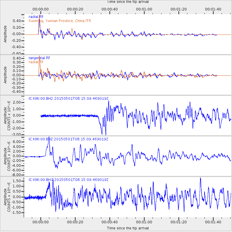
Signal To Noise
| Channel | StoN | STA | LTA |
| IC:KMI:00:BHZ:20150501T08:15:09.469019Z | 41.34824 | 3.1432903E-6 | 7.601993E-8 |
| IC:KMI:00:BH1:20150501T08:15:09.469019Z | 4.5178146 | 4.954525E-7 | 1.09666416E-7 |
| IC:KMI:00:BH2:20150501T08:15:09.469019Z | 12.592495 | 1.0492851E-6 | 8.332623E-8 |
| Arrivals |
| Ps | 4.7 SECOND |
| PpPs | 17 SECOND |
| PsPs/PpSs | 22 SECOND |


