You are here: Home > Network List > KN - Kyrgyz Seismic Telemetry Network Stations List
> Station TKM2 - > Earthquake Result Viewer
TKM2 - - Earthquake Result Viewer
| Earthquake location: |
New Britain Region, P.N.G. |
| Earthquake latitude/longitude: |
-5.2/151.8 |
| Earthquake time(UTC): |
2015/05/01 (121) 08:06:05 GMT |
| Earthquake Depth: |
54 km |
| Earthquake Magnitude: |
7.1 MO |
| Earthquake Catalog/Contributor: |
NEIC PDE/NEIC ALERT |
|
| Network: |
KN Kyrgyz Seismic Telemetry Network |
| Station: |
TKM2 - |
| Lat/Lon: |
42.92 N/75.60 E |
| Elevation: |
2020 m |
|
| Distance: |
83.5 deg |
| Az: |
314.116 deg |
| Baz: |
103.255 deg |
| Ray Param: |
0.04605883 |
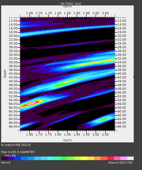
| Estimated Moho Depth: |
55.5 km |
| Estimated Crust Vp/Vs: |
1.66 |
| Assumed Crust Vp: |
6.306 km/s |
| Estimated Crust Vs: |
3.799 km/s |
| Estimated Crust Poisson's Ratio: |
0.22 |
|
| Radial Match: |
96.26216 % |
| Radial Bump: |
378 |
| Transverse Match: |
88.597336 % |
| Transverse Bump: |
400 |
| SOD ConfigId: |
7422571 |
| Insert Time: |
2019-04-18 14:59:45.386 +0000 |
| GWidth: |
2.5 |
| Max Bumps: |
400 |
| Tol: |
0.001 |
|
Signal To Noise
| Channel | StoN | STA | LTA |
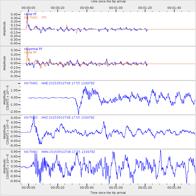
| KN:TKM2: :HHZ:20150501T08:17:55.139978Z | 83.90591 | 2.931306E-6 | 3.493563E-8 |
| KN:TKM2: :HHN:20150501T08:17:55.139978Z | 10.368867 | 2.1189796E-7 | 2.043598E-8 |
| KN:TKM2: :HHE:20150501T08:17:55.139978Z | 35.91445 | 1.0053633E-6 | 2.7993277E-8 |
| Arrivals |
| Ps | 6.0 SECOND |
| PpPs | 23 SECOND |
| PsPs/PpSs | 29 SECOND |


