You are here: Home > Network List > IU - Global Seismograph Network (GSN - IRIS/USGS) Stations List
> Station WVT Waverly, Tennessee, USA > Earthquake Result Viewer
WVT Waverly, Tennessee, USA - Earthquake Result Viewer
| Earthquake location: |
Off East Coast Of Kamchatka |
| Earthquake latitude/longitude: |
52.9/160.1 |
| Earthquake time(UTC): |
1998/06/01 (152) 05:34:03 GMT |
| Earthquake Depth: |
44 km |
| Earthquake Magnitude: |
6.2 MB, 6.3 MS, 6.5 UNKNOWN, 6.4 MW |
| Earthquake Catalog/Contributor: |
WHDF/NEIC |
|
| Network: |
IU Global Seismograph Network (GSN - IRIS/USGS) |
| Station: |
WVT Waverly, Tennessee, USA |
| Lat/Lon: |
36.13 N/87.83 W |
| Elevation: |
157 m |
|
| Distance: |
73.6 deg |
| Az: |
51.434 deg |
| Baz: |
324.181 deg |
| Ray Param: |
0.052820977 |
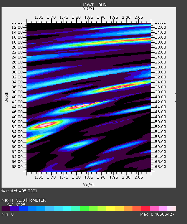
| Estimated Moho Depth: |
51.0 km |
| Estimated Crust Vp/Vs: |
1.67 |
| Assumed Crust Vp: |
6.444 km/s |
| Estimated Crust Vs: |
3.853 km/s |
| Estimated Crust Poisson's Ratio: |
0.22 |
|
| Radial Match: |
95.0321 % |
| Radial Bump: |
371 |
| Transverse Match: |
77.10883 % |
| Transverse Bump: |
400 |
| SOD ConfigId: |
4480 |
| Insert Time: |
2010-03-02 02:02:51.996 +0000 |
| GWidth: |
2.5 |
| Max Bumps: |
400 |
| Tol: |
0.001 |
|

Signal To Noise
| Channel | StoN | STA | LTA |
| IU:WVT: :BHN:19980601T05:45:01.203003Z | 25.749163 | 2.1270603E-6 | 8.260697E-8 |
| IU:WVT: :BHE:19980601T05:45:01.203003Z | 10.81953 | 7.162106E-7 | 6.619609E-8 |
| IU:WVT: :BHZ:19980601T05:45:01.203003Z | 4.9917607 | 4.730827E-7 | 9.4772716E-8 |
| Arrivals |
| Ps | 5.5 SECOND |
| PpPs | 20 SECOND |
| PsPs/PpSs | 26 SECOND |


