You are here: Home > Network List > IU - Global Seismograph Network (GSN - IRIS/USGS) Stations List
> Station WVT Waverly, Tennessee, USA > Earthquake Result Viewer
WVT Waverly, Tennessee, USA - Earthquake Result Viewer
| Earthquake location: |
Near Coast Of Central Chile |
| Earthquake latitude/longitude: |
-32.5/-71.7 |
| Earthquake time(UTC): |
2008/12/18 (353) 21:19:28 GMT |
| Earthquake Depth: |
18 km |
| Earthquake Magnitude: |
5.8 MB, 6.0 MS, 6.2 MW, 6.1 MW |
| Earthquake Catalog/Contributor: |
WHDF/NEIC |
|
| Network: |
IU Global Seismograph Network (GSN - IRIS/USGS) |
| Station: |
WVT Waverly, Tennessee, USA |
| Lat/Lon: |
36.13 N/87.83 W |
| Elevation: |
157 m |
|
| Distance: |
69.9 deg |
| Az: |
346.163 deg |
| Baz: |
165.538 deg |
| Ray Param: |
0.05533771 |
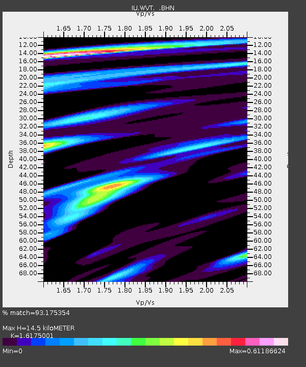
| Estimated Moho Depth: |
14.5 km |
| Estimated Crust Vp/Vs: |
1.62 |
| Assumed Crust Vp: |
6.444 km/s |
| Estimated Crust Vs: |
3.984 km/s |
| Estimated Crust Poisson's Ratio: |
0.19 |
|
| Radial Match: |
93.175354 % |
| Radial Bump: |
317 |
| Transverse Match: |
73.10404 % |
| Transverse Bump: |
317 |
| SOD ConfigId: |
2658 |
| Insert Time: |
2010-03-02 02:03:02.485 +0000 |
| GWidth: |
2.5 |
| Max Bumps: |
400 |
| Tol: |
0.001 |
|

Signal To Noise
| Channel | StoN | STA | LTA |
| IU:WVT: :BHN:20081218T21:30:06.848018Z | 13.482692 | 1.4026613E-6 | 1.0403422E-7 |
| IU:WVT: :BHE:20081218T21:30:06.848018Z | 5.227489 | 4.6689013E-7 | 8.931442E-8 |
| IU:WVT: :BHZ:20081218T21:30:06.848018Z | 3.3273826 | 3.897105E-7 | 1.17122234E-7 |
| Arrivals |
| Ps | 1.4 SECOND |
| PpPs | 5.7 SECOND |
| PsPs/PpSs | 7.1 SECOND |


