You are here: Home > Network List > RV - Regional Alberta Seismic Observatory for Earthquake Studies Network Stations List
> Station WAPA Wapiti River, AB > Earthquake Result Viewer
WAPA Wapiti River, AB - Earthquake Result Viewer
| Earthquake location: |
New Britain Region, P.N.G. |
| Earthquake latitude/longitude: |
-5.2/151.8 |
| Earthquake time(UTC): |
2015/05/01 (121) 08:06:05 GMT |
| Earthquake Depth: |
54 km |
| Earthquake Magnitude: |
7.1 MO |
| Earthquake Catalog/Contributor: |
NEIC PDE/NEIC ALERT |
|
| Network: |
RV Regional Alberta Seismic Observatory for Earthquake Studies Network |
| Station: |
WAPA Wapiti River, AB |
| Lat/Lon: |
55.18 N/119.25 W |
| Elevation: |
784 m |
|
| Distance: |
93.7 deg |
| Az: |
35.073 deg |
| Baz: |
266.183 deg |
| Ray Param: |
0.04119389 |
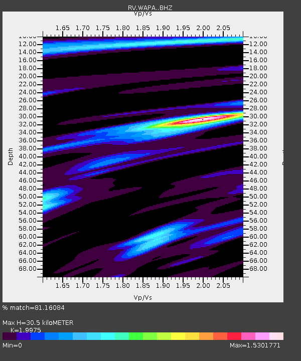
| Estimated Moho Depth: |
30.5 km |
| Estimated Crust Vp/Vs: |
2.00 |
| Assumed Crust Vp: |
6.161 km/s |
| Estimated Crust Vs: |
3.084 km/s |
| Estimated Crust Poisson's Ratio: |
0.33 |
|
| Radial Match: |
81.16084 % |
| Radial Bump: |
400 |
| Transverse Match: |
60.77434 % |
| Transverse Bump: |
400 |
| SOD ConfigId: |
7422571 |
| Insert Time: |
2019-04-18 15:01:02.766 +0000 |
| GWidth: |
2.5 |
| Max Bumps: |
400 |
| Tol: |
0.001 |
|

Signal To Noise
| Channel | StoN | STA | LTA |
| RV:WAPA: :BHZ:20150501T08:18:43.725Z | 11.560678 | 2.5214958E-6 | 2.1810969E-7 |
| RV:WAPA: :BHN:20150501T08:18:43.725Z | 1.4210098 | 5.452497E-7 | 3.837058E-7 |
| RV:WAPA: :BHE:20150501T08:18:43.725Z | 2.4004323 | 9.146293E-7 | 3.8102692E-7 |
| Arrivals |
| Ps | 5.0 SECOND |
| PpPs | 15 SECOND |
| PsPs/PpSs | 20 SECOND |


