You are here: Home > Network List > TA - USArray Transportable Network (new EarthScope stations) Stations List
> Station G59A Clarenceville, QC, USA > Earthquake Result Viewer
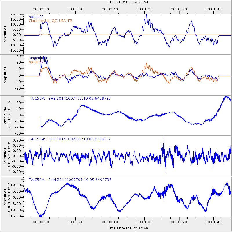
G59A Clarenceville, QC, USA - Earthquake Result Viewer
*The percent match for this event was below the threshold and hence no stack was calculated.
| Earthquake location: |
Northern Chile |
| Earthquake latitude/longitude: |
-19.7/-69.7 |
| Earthquake time(UTC): |
2014/10/07 (280) 05:09:10 GMT |
| Earthquake Depth: |
103 km |
| Earthquake Magnitude: |
5.8 MB |
| Earthquake Catalog/Contributor: |
NEIC PDE/NEIC COMCAT |
|
| Network: |
TA USArray Transportable Network (new EarthScope stations) |
| Station: |
G59A Clarenceville, QC, USA |
| Lat/Lon: |
45.08 N/73.18 W |
| Elevation: |
36 m |
|
| Distance: |
64.5 deg |
| Az: |
357.23 deg |
| Baz: |
176.314 deg |
| Ray Param: |
$rayparam |
*The percent match for this event was below the threshold and hence was not used in the summary stack. |
|
| Radial Match: |
78.328384 % |
| Radial Bump: |
400 |
| Transverse Match: |
75.34451 % |
| Transverse Bump: |
400 |
| SOD ConfigId: |
796777 |
| Insert Time: |
2014-10-21 05:41:41.202 +0000 |
| GWidth: |
2.5 |
| Max Bumps: |
400 |
| Tol: |
0.001 |
|
Signal To Noise
| Channel | StoN | STA | LTA |
| TA:G59A: :BHZ:20141007T05:19:05.649973Z | 1.0023699 | 2.5171605E-7 | 2.511209E-7 |
| TA:G59A: :BHN:20141007T05:19:05.649973Z | 0.39493588 | 5.787735E-6 | 1.4654873E-5 |
| TA:G59A: :BHE:20141007T05:19:05.649973Z | 1.3517786 | 1.3268551E-5 | 9.815624E-6 |
| Arrivals |
| Ps | |
| PpPs | |
| PsPs/PpSs | |


