You are here: Home > Network List > IU - Global Seismograph Network (GSN - IRIS/USGS) Stations List
> Station WVT Waverly, Tennessee, USA > Earthquake Result Viewer
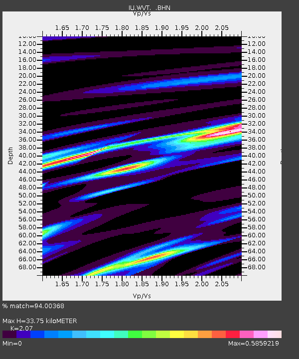
WVT Waverly, Tennessee, USA - Earthquake Result Viewer
| Earthquake location: |
Azores Islands, Portugal |
| Earthquake latitude/longitude: |
38.3/-26.7 |
| Earthquake time(UTC): |
1997/06/27 (178) 04:39:52 GMT |
| Earthquake Depth: |
10 km |
| Earthquake Magnitude: |
5.6 MB, 5.4 MS, 5.9 UNKNOWN, 5.9 MW |
| Earthquake Catalog/Contributor: |
WHDF/NEIC |
|
| Network: |
IU Global Seismograph Network (GSN - IRIS/USGS) |
| Station: |
WVT Waverly, Tennessee, USA |
| Lat/Lon: |
36.13 N/87.83 W |
| Elevation: |
157 m |
|
| Distance: |
47.9 deg |
| Az: |
287.263 deg |
| Baz: |
68.074 deg |
| Ray Param: |
0.06967018 |
| Estimated Moho Depth: |
33.75 km |
| Estimated Crust Vp/Vs: |
2.07 |
| Assumed Crust Vp: |
6.444 km/s |
| Estimated Crust Vs: |
3.113 km/s |
| Estimated Crust Poisson's Ratio: |
0.35 |
|
| Radial Match: |
94.00368 % |
| Radial Bump: |
257 |
| Transverse Match: |
70.72457 % |
| Transverse Bump: |
400 |
| SOD ConfigId: |
4480 |
| Insert Time: |
2010-03-02 02:03:13.246 +0000 |
| GWidth: |
2.5 |
| Max Bumps: |
400 |
| Tol: |
0.001 |
|

Signal To Noise
| Channel | StoN | STA | LTA |
| IU:WVT: :BHN:19970627T04:48:00.339008Z | 4.416517 | 1.9601589E-7 | 4.438246E-8 |
| IU:WVT: :BHE:19970627T04:48:00.339008Z | 1.6767291 | 7.1713856E-8 | 4.277009E-8 |
| IU:WVT: :BHZ:19970627T04:48:00.339008Z | 3.3030646 | 1.5975725E-7 | 4.836637E-8 |
| Arrivals |
| Ps | 5.9 SECOND |
| PpPs | 15 SECOND |
| PsPs/PpSs | 21 SECOND |


