You are here: Home > Network List > TA - USArray Transportable Network (new EarthScope stations) Stations List
> Station K27K Chicken, AK, USA > Earthquake Result Viewer
K27K Chicken, AK, USA - Earthquake Result Viewer
| Earthquake location: |
New Britain Region, P.N.G. |
| Earthquake latitude/longitude: |
-5.2/151.8 |
| Earthquake time(UTC): |
2015/05/01 (121) 08:06:05 GMT |
| Earthquake Depth: |
54 km |
| Earthquake Magnitude: |
7.1 MO |
| Earthquake Catalog/Contributor: |
NEIC PDE/NEIC ALERT |
|
| Network: |
TA USArray Transportable Network (new EarthScope stations) |
| Station: |
K27K Chicken, AK, USA |
| Lat/Lon: |
64.03 N/142.08 W |
| Elevation: |
389 m |
|
| Distance: |
84.5 deg |
| Az: |
23.864 deg |
| Baz: |
246.222 deg |
| Ray Param: |
0.04535662 |
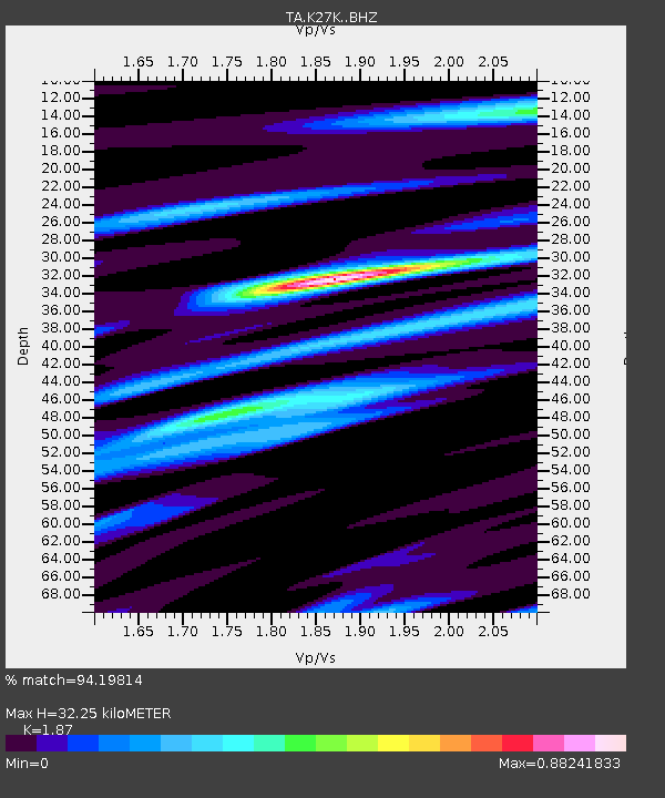
| Estimated Moho Depth: |
32.25 km |
| Estimated Crust Vp/Vs: |
1.87 |
| Assumed Crust Vp: |
6.566 km/s |
| Estimated Crust Vs: |
3.511 km/s |
| Estimated Crust Poisson's Ratio: |
0.30 |
|
| Radial Match: |
94.19814 % |
| Radial Bump: |
380 |
| Transverse Match: |
79.83065 % |
| Transverse Bump: |
400 |
| SOD ConfigId: |
7422571 |
| Insert Time: |
2019-04-18 15:01:32.766 +0000 |
| GWidth: |
2.5 |
| Max Bumps: |
400 |
| Tol: |
0.001 |
|

Signal To Noise
| Channel | StoN | STA | LTA |
| TA:K27K: :BHZ:20150501T08:18:00.300012Z | 33.352917 | 3.2759629E-6 | 9.8221186E-8 |
| TA:K27K: :BHN:20150501T08:18:00.300012Z | 3.0021238 | 3.0963773E-7 | 1.03139556E-7 |
| TA:K27K: :BHE:20150501T08:18:00.300012Z | 9.192478 | 1.1135115E-6 | 1.211329E-7 |
| Arrivals |
| Ps | 4.4 SECOND |
| PpPs | 14 SECOND |
| PsPs/PpSs | 18 SECOND |


